WFIGS·
Containment updated from 40% to 50%.
Active Wildfire · Sutton County, TX
Opens in the app — start as a guest, no account needed
From the ground
Photos are gathered from official agency and local social sources and shown with attribution. Always follow official evacuation orders.
Containment updated from 40% to 50%.
Personnel updated to 66. Fire behavior: Active.
As of Sep 17, 2026, 4:19 PM MDT: The Dry River Fire is burning in Sutton County and has reached an estimated 8,939 acres with 40% containment.
🤖 AI summary of official posts; may lag or contain errors — verify with the source and official channels.
Acreage updated from 8,761 to 8,939 acres.
As of Sep 17, 2026, 10:58 AM MDT: The Dry River Fire is burning in Sutton County and is partially contained.
🤖 AI summary of official posts; may lag or contain errors — verify with the source and official channels.
Containment updated from 30% to 40%.
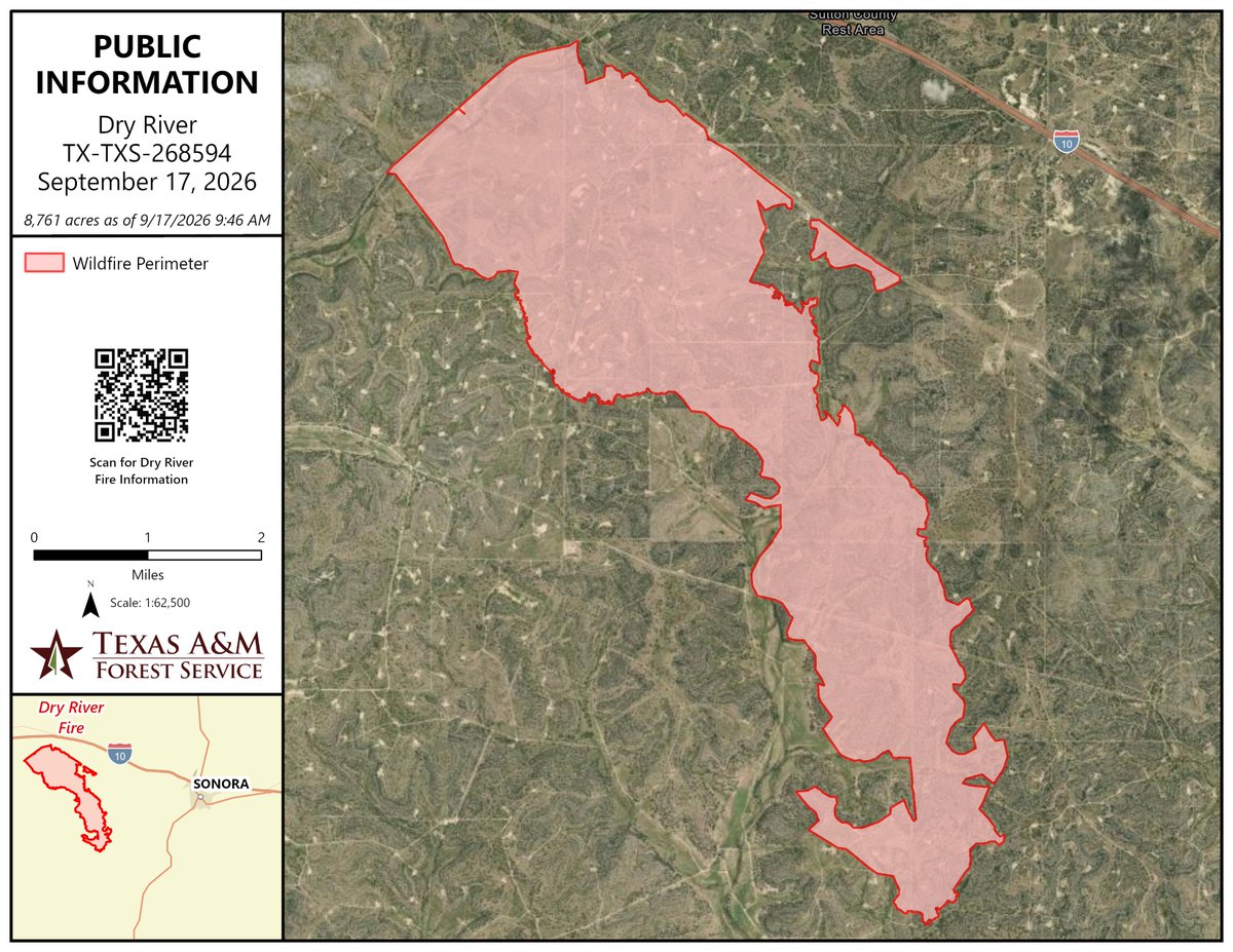
As of Sep 17, 2026, 9:13 AM MDT: The Dry River Fire is burning in Sutton County, Texas.
🤖 AI summary of official posts; may lag or contain errors — verify with the source and official channels.
As of Sep 17, 2026, 6:11 AM MDT: The Dry River Fire is burning in Sutton County with active suppression efforts ongoing. Firefighters worked overnight to build containment line and extinguish flames along the flanks.
🤖 AI summary of official posts; may lag or contain errors — verify with the source and official channels.
Acreage updated from 7,000 to 8,761 acres. Containment updated from 25% to 30%.
Personnel updated to 113.
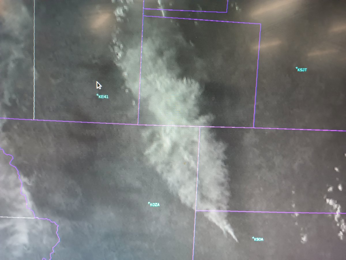


As of Sep 16, 2026, 6:13 PM MDT: The Dry River Fire is burning in Sutton County, Texas, with a large smoke plume visible extending north-northwest across southern and western Irion County and far eastern Reagan County.
🤖 AI summary of official posts; may lag or contain errors — verify with the source and official channels.
As of Sep 16, 2026, 5:17 PM MDT: The Dry River Fire in Sutton County has increased in activity this afternoon, with significant smoke impacts reported in the area.
🤖 AI summary of official posts; may lag or contain errors — verify with the source and official channels.
Acreage updated from 5,500 to 7,000 acres.

As of Sep 16, 2026, 7:28 AM MDT: The Dry River Fire is burning in Sutton County, Texas, with an estimated preliminary perimeter of 5,500 acres as of September 16, 2026.
🤖 AI summary of official posts; may lag or contain errors — verify with the source and official channels.
As of Sep 16, 2026, 5:22 AM MDT: The Dry River Fire in Sutton County remains active, with crews continuing suppression efforts and containment line construction overnight.
🤖 AI summary of official posts; may lag or contain errors — verify with the source and official channels.
Acreage updated from 3,500 to 5,500 acres. Containment updated from 10% to 25%.
21 personnel deployed. Fire behavior: Extreme.
Acreage updated from 2,000 to 3,500 acres. Containment updated from 0% to 10%.
As of Sep 15, 2026, 7:05 PM MDT: The Dry River Fire is burning west of Sonora and is in close proximity to Interstate 10. Smoke is reducing visibility in the area, posing a hazard to drivers.
🤖 AI summary of official posts; may lag or contain errors — verify with the source and official channels.
As of Sep 15, 2026, 5:59 PM MDT: The Dry River Fire is burning in Sutton County and exhibiting extreme fire activity with no containment.
🤖 AI summary of official posts; may lag or contain errors — verify with the source and official channels.
Acreage updated from 1,200 to 2,000 acres.

As of Sep 15, 2026, 4:28 PM MDT: The Dry River Fire is burning in Sutton County, Texas, with active firefighting operations underway. No containment has been achieved as of the latest update.
🤖 AI summary of official posts; may lag or contain errors — verify with the source and official channels.
Acreage updated from 400 to 1,200 acres.
TXTXS Dry River Fire: Last updated: --- The type of incident is Wildfire and involves the following unit(s) Texas A&M Forest Service. --- State: Texas --- Coordinates: Latitude: 30° 32 2705 Longitude: 100° 44 40.1 --- ...
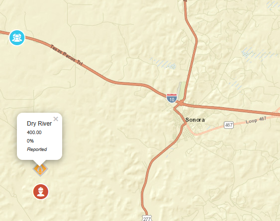
As of Sep 15, 2026, 3:03 PM MDT: Texas A&M Forest Service is responding to the Dry River Fire in Sutton County. The fire is estimated at 400 acres and 0% contained.
🤖 AI summary of official posts; may lag or contain errors — verify with the source and official channels.
First report.
New fire reported. Acres: 400. Containment: 0%. Cause: Undetermined.
Free · iPhone & iPad · Official + local sources · Start as a guest, no account needed
Example alerts
Data from official wildfire feeds and local agencies, refreshed regularly but not guaranteed real-time. Always follow official evacuation orders from local authorities.