Active incidentUpdated

Active Wildfire · Grand County, UT

Slough Canyon Firenear Grand County, UT

Opens in the app — start as a guest, no account needed

95%
Contained
Size
4,774acres
Status
Active
Discovered

From the ground

Latest photos from the fire

6 images · gathered by AI Discovery from official & local sources

Photos are gathered from official agency and local social sources and shown with attribution. Always follow official evacuation orders.

Live in the appThe perimeter updates as agencies publish it.Open live map →
Current fire perimeter4,774 acres · updated

Updates

· AI Discovery

As of Aug 30, 2026, 9:55 AM MDT: The Slough Canyon Fire has received over an inch of rain in the last 24 hours, significantly moderating fire behavior. Some resources are being demobilized as the incident transitions to a lower complexity organization. Current situation: Weather: Evacuations and closures: Fire information contact: Jordan Nesbitt, (435) 459-0935 or jnesbitt@blm.gov (per Utah Fire Info (Facebook))

  • Start date: August 15, 2026 (per Utah Fire Info (Facebook))
  • Cause: Lightning (per Utah Fire Info (Facebook))
  • Location: 41 miles east of Price, UT, in a remote area of the Book Cliffs on Uintah and Ouray Tribal Lands (per Utah Fire Info (Facebook); location detail per Wildfire news article)
  • Size: 4,742 acres (per Utah Fire Info (Facebook))
  • Containment: 34% (per Utah Fire Info (Facebook))
  • Total personnel: 49 (per Utah Fire Info (Facebook))
  • Managing agency includes Bureau of Indian Affairs (per Wildfire news article)
  • Over an inch of rain has fallen over the fire area in the last 24 hours, moderating fire behavior; pockets of heat will remain in canyons as heavy timber holds heat (per Utah Fire Info (Facebook))
  • Remaining uncontained line is within canyons where mop-up operations are not safe; containment in those areas will be confirmed over time via infrared heat detection flights (per Utah Fire Info (Facebook))
  • The incident will transition to a lower complexity Type 4 organization tomorrow, Monday, August 31 (per Utah Fire Info (Facebook))
  • This is the last official update for this fire; future updates will appear on the Utah Fire Info Facebook page only if fire behavior becomes more active (per Utah Fire Info (Facebook))
  • Showers continuing today with periods of heavy rain; thunderstorms over the fire area with gusty outflow winds up to 25 mph; this pattern continues through Monday (per Utah Fire Info (Facebook))
  • No evacuations are currently in place (per Utah Fire Info (Facebook))
  • No safety threat to Desolation Canyon and the Green River (per Utah Fire Info (Facebook))
  • Public access is closed from Horse Corn Road at the Grand County line to the Chicken Ridge junction (per Utah Fire Info (Facebook))

🤖 AI summary of official posts and linked news coverage; may lag or contain errors — verify with the source and official channels. ⚠️ Not an official evacuation order — follow your sheriff/emergency management.
· AI Discovery

As of Aug 29, 2026, 11:50 AM MDT: The Slough Canyon Fire is burning in a remote area of Grand County on Tribal Trust Lands within the Uintah and Ouray Reservation, approximately 41 miles east of Price, UT. Containment has increased to 36% following precipitation that helped moderate fire behavior.

  • Start date: August 15, 2026 (per Utah Fire Info · Facebook)
  • Cause: Lightning (per Utah Fire Info · Facebook)
  • Size: 4,668 acres (per Utah Fire Info · Facebook)
  • Containment: 36% (per Utah Fire Info · Facebook)
  • Total personnel: 77 (per Utah Fire Info · Facebook)
  • The fire is managed by a Type 3 organization (per Utah Fire Info · Facebook)
  • Fire information contact: Jordan Nesbitt, (435) 459-0935 or jnesbitt@blm.gov (per Utah Fire Info · Facebook)
  • Initial attack response included two helicopters and two engines (per Wildfire · news article)
  • Direct ground engagement remains unsafe in the heavy mixed-conifer stands and steep canyons; crews are constructing containment lines on the plateau and utilizing natural barriers such as bare canyon walls and ridges (per Wildfire · news article)
  • Crews continue to hold and improve containment lines around all edges of the fire; the fire burning within the canyons still has the potential to move onto the plateau (per Utah Fire Info · Facebook)
  • Fire activity will remain in the canyon drainages; heavy mixed-conifer stands will continue to smolder until prolonged rains occur or until snow falls; isolated pockets of smoke may be visible for weeks to come (per Utah Fire Info · Facebook)
  • Weather today: periods of rain expected with gusty winds up to 25 mph when storms are present; chance of thunderstorms increases into the afternoon, bringing gusty outflow winds and potential lightning; otherwise partly sunny with winds out of the southwest at 10–15 mph (per Utah Fire Info · Facebook)
  • Similar weather patterns are forecast for tomorrow (per Utah Fire Info · Facebook)
  • Road closure: No public access from the Horse Corn Road at the Grand County line to the Chicken Ridge junction (per Utah Fire Info · Facebook)
  • No evacuations are currently in place (per Utah Fire Info · Facebook)
  • No safety threat to Desolation Canyon and the Green River (per Utah Fire Info · Facebook)

🤖 AI summary of official posts and linked news coverage; may lag or contain errors — verify with the source and official channels. ⚠️ Not an official evacuation order — follow your sheriff/emergency management.
· AI Discovery

As of Aug 28, 2026, 2:26 PM MDT: The Slough Canyon Fire, ignited by lightning on August 15, 2026, is burning in a remote area of the Book Cliffs approximately 41 miles east of Price, UT, and has reached 25% containment following strong crew efforts along the northern edge of the fire.

  • Start date: August 15, 2026; cause: lightning (per Utah Fire Info (Facebook))
  • Location: 41 miles east of Price, UT (per Utah Fire Info (Facebook))
  • Size: 4,668 acres (per Utah Fire Info (Facebook))
  • Containment: 25% (per Utah Fire Info (Facebook))
  • Total personnel: 77 (per Utah Fire Info (Facebook))
  • Containment was added along the northern edge near Pinto and Moonwater Canyons (per Utah Fire Info (Facebook))
  • The fire started on Uintah and Ouray Tribal Lands; initial attack included two helicopters and two engines (per Wildfire news article)
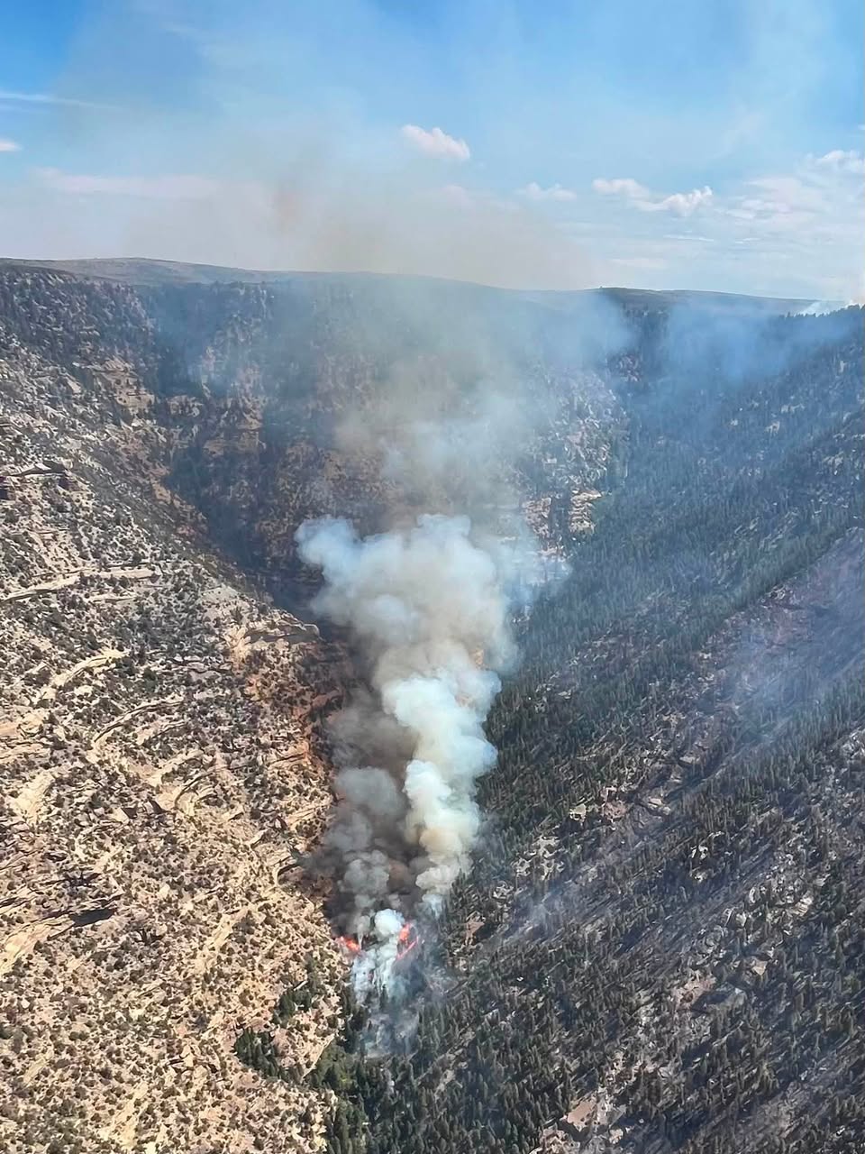
  • The fire remains active below the rim, burning in mixed-conifer in multiple canyon drainages; it is unsafe for firefighters to engage in the canyons, so all suppression actions are taking place on the plateau (per Utah Fire Info (Facebook))
  • Crews are constructing containment lines on the plateau and utilizing natural barriers such as bare canyon walls and ridges (per Wildfire news article)
  • Along Moonwater Road toward Big Doggie Canyon, crews are cutting brush to improve the road as a holding feature (per Utah Fire Info (Facebook))
  • Unmanned Aerial Systems (UAS) are being used across the entire fire to detect hot spots, including in canyons where ground engagement is unsafe (per Utah Fire Info (Facebook))
  • Weather: cloud cover increasing today with short bursts of rain; winds out of the southwest at 10–15 mph with gusts up to 25 mph; chance of precipitation and thunderstorms increases through the weekend with possibility of strong outflow winds (per Utah Fire Info (Facebook))
  • Smoke will be visible from Green River, the I-70 corridor, and the Uintah Basin (per Utah Fire Info (Facebook))
  • Road closure: no public access from Horse Corn Road at the Grand County line to the Chicken Ridge junction (per Utah Fire Info (Facebook))
  • No evacuations are currently in place; no safety threat to Desolation Canyon and the Green River (per Utah Fire Info (Facebook))
  • Fire information contact: Jordan Nesbitt, (435) 459-0935 or jnesbitt@blm.gov (per Utah Fire Info (Facebook))

🤖 AI summary of official posts and linked news coverage; may lag or contain errors — verify with the source and official channels. ⚠️ Not an official evacuation order — follow your sheriff/emergency management.
· AI Discovery

As of Aug 25, 2026, 11:03 AM MDT: The Slough Canyon Fire is an active wildfire burning in steep canyon terrain within the Book Cliffs on Uintah and Ouray Tribal Lands, approximately 41 miles east of Price, UT. It remains at 0% containment with firefighter and public safety the highest priority.

  • Start date: August 15, 2026 (per Utah Fire Info (Facebook))
  • Cause: Lightning (per Utah Fire Info (Facebook))
  • Location: 41 miles east of Price, UT, in a remote area of the Book Cliffs on Uintah and Ouray Tribal Lands east of Desolation Canyon (per Utah Fire Info (Facebook))
  • Size: 3,062 acres (per Utah Fire Info (Facebook))
  • Containment: 0% (per Utah Fire Info (Facebook))
  • Total personnel: 75 (per Utah Fire Info (Facebook))
  • Managing agency: Bureau of Indian Affairs (per Wildfire news article)
  • Initial attack response included two helicopters and two engines (per Wildfire news article)
  • Fire is making uphill runs, producing spotting distances of approximately ¼ to ½ mile onto the plateau (per Utah Fire Info (Facebook))
  • Firefighters have built containment lines off the western edge toward Moonwater Point using a combination of dozer and handline; strategic firing operations are planned today to reduce dense fuels and strengthen those lines (per Utah Fire Info (Facebook))
  • On the south and east edges, the fire continues to back downslope toward Florence Creek and into steep canyons; dozerline is being constructed along the rim in preparation for forecasted strong southwest winds on Friday (per Utah Fire Info (Facebook))
  • Mop-up operations are underway on the northern edge where the fire made a sustained run on Saturday (per Utah Fire Info (Facebook))
  • Direct ground engagement remains unsafe in the heavy mixed-conifer stands and steep canyons; suppression actions are focused on the plateau (per Wildfire news article)
  • Temperatures will remain in the mid to upper 80s today; winds out of the south and west at 5–10 mph; storms possible this afternoon with gusty outflow winds up to 40 mph and no wetting rain expected (per Utah Fire Info (Facebook))
  • Relative humidities will stay between 15–20% with poor overnight recoveries (per Wildfire news article)
  • Critical fire weather conditions, including strong winds and low relative humidity, are expected Friday (per Utah Fire Info (Facebook))
  • A smoke column from planned firing operations will be visible from Green River, the I-70 corridor, and the Uintah Basin (per Utah Fire Info (Facebook))
  • Road closure: No public access from Horse Corn Road at the Grand County line to the Chicken Ridge junction (per Utah Fire Info (Facebook))
  • Currently no evacuations in place and no safety threat to Desolation Canyon and the Green River (per Utah Fire Info (Facebook))
  • Fire information contact: Jordan Nesbitt, (435) 459-0935 or jnesbitt@blm.gov (per Utah Fire Info (Facebook))

🤖 AI summary of official posts and linked news coverage; may lag or contain errors — verify with the source and official channels. ⚠️ Not an official evacuation order — follow your sheriff/emergency management.
· AI Discovery

As of Aug 24, 2026, 4:42 PM MDT: The Slough Canyon Fire is an active, uncontained wildfire burning in the Book Cliffs on Uintah and Ouray Tribal Lands east of Desolation Canyon, approximately 41 miles east of Price, UT. Fire behavior remains aggressive in steep, inaccessible terrain with uphill runs onto surrounding plateaus.

  • Start date: August 15, 2026 (per Utah Fire Info (Facebook))
  • Cause: Lightning (per Utah Fire Info (Facebook))
  • Location: 41 miles east of Price, UT, in a remote area of the Book Cliffs on Uintah and Ouray Tribal Lands east of Desolation Canyon (per Utah Fire Info (Facebook))
  • Size: 2,897 acres (per Utah Fire Info (Facebook))
  • Containment: 0% (per Utah Fire Info (Facebook))
  • Total personnel: 72 (per Utah Fire Info (Facebook))
  • Managing agency: Bureau of Indian Affairs (per Wildfire news article)
  • Initial attack response included two helicopters and two engines (per Wildfire news article)
  • Direct ground engagement remains unsafe in heavy mixed-conifer stands and steep canyons (per Utah Fire Info (Facebook))
  • Crews are conducting firing operations off completed dozerlines and constructing additional dozerline along the rim near Slough Canyon Point (per Utah Fire Info (Facebook))
  • Strategic firing operations and holding features are being created east of Moonwater Point and west of Chandler Canyon (per Wildfire news article)
  • Aerial resources have been utilized for retardant drops along the mesa (per Utah Fire Info (Facebook))
  • Fire behavior: active in timber with uphill runs out of canyons onto plateaus; active fire behavior observed in grass and sagebrush on top; gusty outflow winds from thunderstorms are the main concern (per Utah Fire Info (Facebook))
  • Weather: daily high temperatures in the mid to upper 80s through the first half of the week; relative humidity 15–20% with poor overnight recoveries; winds variable and up to 10 mph with chance of gusty outflow winds; wetting rain unlikely; potential for critical fire weather increases toward the weekend with strong western winds (per Utah Fire Info (Facebook))
  • Smoke will be visible from Green River, the I-70 corridor, and the Uintah Basin (per Utah Fire Info (Facebook))
  • Road closure: No public access from the Horse Corn Road at the Grand County line to the Chicken Ridge junction (per Utah Fire Info (Facebook))
  • No evacuations are currently in place; no safety threat to Desolation Canyon and the Green River (per Utah Fire Info (Facebook))
  • Fire information contact: Jordan Nesbitt, (435) 459-0935 or jnesbitt@blm.gov (per Utah Fire Info (Facebook))

🤖 AI summary of official posts and linked news coverage; may lag or contain errors — verify with the source and official channels. ⚠️ Not an official evacuation order — follow your sheriff/emergency management.
· AI Discovery

As of Aug 22, 2026, 6:52 PM MDT: The Slough Canyon Fire, sparked by lightning on August 15, 2026, approximately 41 miles east of Price, UT, has grown rapidly to an estimated 2,700 acres with 0% containment, driven by extreme fire behavior and shifting winds.

  • Start date: August 15, 2026; cause: lightning (per Utah Fire Info · Facebook)
  • Location: 41 miles east of Price, UT (per Utah Fire Info · Facebook)
  • Size: approximately 2,700 acres — note the fire was mapped at 810 acres around noon the same day before significant expansion (per Utah Fire Info · Facebook)
  • Containment: 0% (per Utah Fire Info · Facebook)
  • Total personnel: 42 (per Utah Fire Info · Facebook)
  • Fire growth has pushed primarily to the northeast, crossing a constructed dozer line on the mesa top near Slough Canyon Point and into Pinto Canyon and Moonwater Canyon (per Utah Fire Info · Facebook)
  • Direct ground engagement is unsafe in heavy mixed-conifer stands and steep canyon walls; crews are re-evaluating control lines and utilizing natural barriers (per Utah Fire Info · Facebook)
  • Gusts up to 30 mph with erratic outflow winds may continue to drive active fire behavior; minimum relative humidity dropping into the teens to mid-20s during the day (per Utah Fire Info · Facebook)
  • Monsoonal moisture may bring scattered showers and thunderstorms through the weekend; chance of wetting rain is 10% to 20%; isolated storms raise concerns for flash flooding and debris flows (per Utah Fire Info · Facebook)
  • Smoke will be visible from Green River, the I-70 corridor, and the Uintah Basin (per Utah Fire Info · Facebook)
  • No evacuations are in place; no safety impacts to Desolation Canyon or the Green River; no anticipated road closures or area closures (per Utah Fire Info · Facebook)
  • Fire information contact: Blake Johnson, (385) 460-0760 or blake_johnson@ios.doi.gov (per Utah Fire Info · Facebook)

🤖 AI summary of official posts; may lag or contain errors — verify with the source and official channels. ⚠️ Not an official evacuation order — follow your sheriff/emergency management.

· AI Discovery

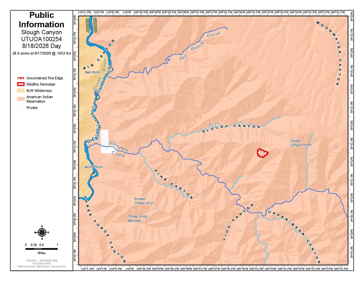
As of Aug 18, 2026, 4:46 PM MDT: The Slough Canyon Fire is burning in a remote area and is estimated at approximately 80 acres. Two helicopters and two engines are assigned to the fire, though helicopter waterdrops have had little effect on slowing fire spread.

  • Size: ~80 acres (per Utah Fire Info · Facebook)
  • Resources assigned: two helicopters and two engines (per Utah Fire Info · Facebook)
  • Strategy: full suppression effort, with plans to use natural features to contain the fire and construct indirect line across the top of the plateau to limit spread to the east and north (per Utah Fire Info · Facebook)
  • Smoke may be visible from Green River and the I-70 corridor (per Utah Fire Info · Facebook)
  • No safety impacts to Desolation Canyon and the Green River at this time (per Utah Fire Info · Facebook)
  • No anticipated road closures or area closures associated with the fire (per Utah Fire Info · Facebook)

🤖 AI summary of official posts; may lag or contain errors — verify with the source and official channels.

Know if this fire gets close to you.Set an alert zone and get a push if a fire comes near it or grows — free.Follow this fire

Don't refresh this page. Let it find you.

  • Alerts when it heads your way — a push if the fire comes within your zone's radius, gets closer, or grows sharply.
  • Live perimeter & growth — watch the fire move on the map as agencies update it.
  • Draw a zone around home — or anywhere your people are — and get the lead time to act.

Free · iPhone & iPad · Official + local sources · Start as a guest, no account needed

Example alerts

Data from official wildfire feeds and local agencies, refreshed regularly but not guaranteed real-time. Always follow official evacuation orders from local authorities.

Slough Canyon FireActive · 4,774 ac · 95% containedFollow