Personnel updated to 9.
Active Wildfire · Ouray County, CO
Gold Mountain Firenear Ouray County, CO
Opens in the app — start as a guest, no account needed
From the ground
Latest photos from the fire
Photos are gathered from official agency and local social sources and shown with attribution. Always follow official evacuation orders.
Updates


As of Sep 15, 2026, 4:53 PM MDT: The Gold Mountain Fire closure area on the GMUG National Forests' Ouray Ranger District has been reduced, reopening several popular recreation corridors while a number of roads and trails remain closed due to post-fire hazards. Firefighters continue to actively patrol, monitor, and perform suppression work across the fire area.
- The GMUG National Forests' Ouray Ranger District reduced the Gold Mountain Fire closure area beginning Sept. 15, 2026 at 12:01 a.m. (per U.S. Forest Service-Grand Mesa, Uncompahgre & Gunnison National Forests · Facebook)
- Reopened corridors include Owl Creek Pass, West Fork, East Fork, and the Silver Jack area. (per U.S. Forest Service-Grand Mesa, Uncompahgre & Gunnison National Forests · Facebook)
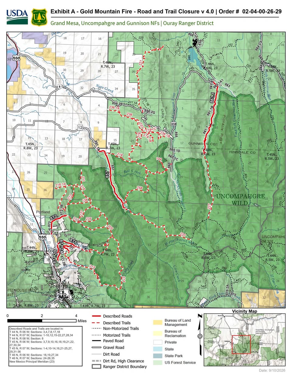
- Roads remaining closed include Middle Fork Cimarron Road NFSR 861.1, Cow Creek Road NFSR 857, Dexter Creek Road NFSR 871, Cutler Road NFSR 872, Jackass Flats Road NFSR 871.2, and Blowout Road NFSR 871.2B. (per Usda · news article)
- Numerous trails remain closed, including Okeson (137), Shortcut (138), Courthouse Mountain (144), Dexter Creek (205), Cobbs Gulch (211), Storm Gulch (212), Difficulty Creek (214), Horsethief (215), Baldy (216), Cutler Creek (217), Courthouse (218), Cow Creek (220), Middle Fork (227), and others. (per Usda · news article)
- The updated closure order is designated Order Number 02-04-06-26-29 and is in effect from September 15, 2026 at 0001 through May 31, 2027 at 1200, unless rescinded. (per Usda · news article)
- The purpose of the remaining closures is to protect public safety due to active pockets of wildfire, hazard trees, residual heat, and mudslides within the wildfire footprint. (per Usda · news article)
- Hazards in recently burned areas include falling trees or snags, rolling debris, unstable ground, holes from burned root systems, airborne particulates, lingering smoke, displaced wildlife, smoldering embers or ash pits, and the potential for flash flooding. (per U.S. Forest Service-Grand Mesa, Uncompahgre & Gunnison National Forests · Facebook)
- Persons needing access to private property from Dexter Creek Road NFSR 871, Cutler Road NFSR 872, or Jackass Flats Road NFSR 871.2 are exempt from the closure order. (per Usda · news article)
- Violations of the closure order are punishable as a Class B misdemeanor by a fine of not more than $5,000 for individuals and $10,000 for organizations, or imprisonment for not more than six months, or both. (per Usda · news article)
- For questions, contact the Ouray Ranger District in Montrose, CO at (970) 240-5300. (per Usda · news article)
🤖 AI summary of official posts and linked news coverage; may lag or contain errors — verify with the source and official channels.

As of Sep 15, 2026, 8:48 AM MDT: All forest closures in Hinsdale County associated with the Gold Mountain Fire have been rescinded, effective September 15. There are now no lands in Hinsdale County closed due to summer wildfires.
- All forest closures in Hinsdale County associated with the Gold Mountain Fire have been rescinded as of September 15 (per Hinsdale County, Colorado · Facebook).
- Trails in the western areas of Hinsdale County now open include East Fork, Middle Fork, Cow Creek, Coxcomb, and Porphyry (per Hinsdale County, Colorado · Facebook).
- GMUG fire personnel have removed closure signs from trailheads in the area (per Hinsdale County, Colorado · Facebook).
- Although closures are lifted, the Forest Service cautions that reopening does not mean these landscapes are safe or that fire operations have stopped; burned terrain can shift without warning and hazards remain within fire footprints (per U.S. Forest Service-Grand Mesa, Uncompahgre & Gunnison National Forests · Facebook).
- Post-fire hazards noted include weather-triggered mudslides, landslides, debris flows and flash floods; holes and loose soil from weakened root systems; unstable trees and snags; lingering heat from smoldering embers and ash pits; smoke and particulates affecting air quality; and displaced wildlife behaving unpredictably (per U.S. Forest Service-Grand Mesa, Uncompahgre & Gunnison National Forests · Facebook).
- The Forest Service states that visiting recently burned areas is not recommended, and may still adjust access, routes, or recreation sites as needed to protect public safety (per U.S. Forest Service-Grand Mesa, Uncompahgre & Gunnison National Forests · Facebook).
🤖 AI summary of official posts; may lag or contain errors — verify with the source and official channels.

As of Sep 14, 2026, 1:06 PM MDT: The GMUG National Forests' Ouray Ranger District is reducing the closure area associated with the Gold Mountain Fire, reopening several popular recreation corridors while keeping certain roads and trails closed due to post-fire hazards. Firefighters continue to actively patrol, monitor, and perform suppression work across the fire area. Closure reduction effective date: Two sources give slightly different times — Montrose Fire District states the reduction begins Sept. 14 at 9 a.m. (per Montrose Fire District · Facebook), while Ouray County Government, Ouray County Sheriff's Office, Ouray County Emergency Management, and USDA all state the reduction begins Sept. 15 at 12:01 a.m. (per Ouray County Government · Facebook; per Ouray County Sheriff's Office · Facebook; per Ouray County Emergency Management · Facebook; per USDA). Corridors reopening: Owl Creek Pass, West Fork, East Fork, and the Silver Jack area will reopen as part of the closure reduction (per Ouray County Sheriff's Office · Facebook). Roads and trails remaining closed due to inaccessibility and post-fire hazards include: Middle Fork Cimarron Road NFSR 861.1, Cow Creek Road NFSR 857, Dexter Creek Road NFSR 871, Cutler Road NFSR 872, Jackass Flats Road NFSR 871.2, and Blowout Road NFSR 871.2B (per USDA). Closed trails include: 137-Okeson, 138-Shortcut, 144-Courthouse Mountain, 205-Dexter Creek, 211-Cobbs Gulch, 212-Storm Gulch, 214-Difficulty Creek, 215-Horsethief, 216-Baldy, 216.1A-Baldy Peak, 217-Cutler Creek, 218-Courthouse, 219-Stealey Mountain North, 219.1B and 219.1C-Stealey Mountain Spurs, 220-Cow Creek, 221-Nate Creek, 227-Middle Fork, 235-Left Fork Cutler Creek, 236-Old Owl Creek, 236.1A and 236.1B-Old Owl Creek Spurs, 237-Spalding Park, and 258-Stealey Mountain South (per USDA). Order number: #02-04-06-26-29. The closure order is in effect from September 15, 2026 at 0001 through May 31, 2027 at 1200, unless rescinded (per USDA). Exemptions to the closure order include persons needing access to private property from Dexter Creek Road NFSR 871, Cutler Road NFSR 872, or Jackass Flats Road NFSR 871.2; persons with Forest Service Permit No. FS-7700-48; and any federal, state, or local officer or member of an organized rescue or firefighting force in the performance of an official duty (per USDA). Purpose of remaining closures: Active pockets of wildfire, hazard trees, residual heat, and mudslides pose a risk to recreationists on restricted roads and trails within the wildfire footprint (per USDA). Hazards in recently burned areas include falling trees or snags, rolling debris, unstable ground, holes from burned root systems, airborne particulates, lingering smoke, displaced wildlife, smoldering embers or ash pits, and the potential for flash flooding and other weather-triggered hazards (per Ouray County Emergency Management · Facebook). Violations of the closure order are punishable as a Class B misdemeanor by a fine of not more than $5,000 for individuals and $10,000 for organizations, or imprisonment for not more than six months, or both (per USDA). Contact for questions: Ouray Ranger District, (970) 240-5300 (per USDA).
🤖 AI summary of official posts and linked news coverage; may lag or contain errors — verify with the source and official channels.


As of Sep 14, 2026, 1:42 PM MDT: The closure area associated with the Gold Mountain Fire on the GMUG National Forests' Ouray Ranger District is being reduced, reopening several popular travel and recreation corridors while certain roads and trails remain closed due to post-fire hazards.
- The closure reduction reopens Owl Creek Pass, West Fork, East Fork, and the Silver Jack area (per U.S. Forest Service-Grand Mesa, Uncompahgre & Gunnison National Forests · Facebook).
- The Facebook post states the closure reduction began Sept. 14 at 9 a.m.; the USDA source states the closure reduction begins Sept. 15 at 12:01 a.m. under Order Number 02-04-06-26-29. Both sources describe the Gold Mountain Fire closure reduction on the Ouray Ranger District (per U.S. Forest Service-Grand Mesa, Uncompahgre & Gunnison National Forests · Facebook; per USDA news article).
- Roads remaining closed include: Middle Fork Cimarron Road NFSR 861.1, Cow Creek Road NFSR 857, Dexter Creek Road NFSR 871, Cutler Road NFSR 872, Jackass Flats Road NFSR 871.2, and Blowout Road NFSR 871.2B (per USDA news article).
- Numerous trails remain closed, including Okeson (137), Shortcut (138), Courthouse Mountain (144), Dexter Creek (205), Cobbs Gulch (211), Storm Gulch (212), Difficulty Creek (214), Horsethief (215), Baldy (216), Cutler Creek (217), Cow Creek (220), Middle Fork (227), and others (per USDA news article).
- Persons needing access to private property from Dexter Creek Road NFSR 871, Cutler Road NFSR 872, or Jackass Flats Road NFSR 871.2 are exempt from the closure order (per USDA news article).
- The closure order is in effect through May 31, 2027 at 1200, unless rescinded (per USDA news article).
- Active pockets of wildfire, hazard trees, residual heat, and mudslides pose a risk to recreationists within the wildfire footprint (per USDA news article).
- Firefighters continue to actively patrol, monitor, and perform suppression work across the fire area as needed (per U.S. Forest Service-Grand Mesa, Uncompahgre & Gunnison National Forests · Facebook).
- Visitors entering recently burned areas may encounter falling trees or snags, rolling debris, unstable ground, holes from burned root systems, airborne particulates, lingering smoke, displaced wildlife, smoldering embers or ash pits, and the potential for flash flooding and other weather-triggered hazards (per U.S. Forest Service-Grand Mesa, Uncompahgre & Gunnison National Forests · Facebook).
🤖 AI summary of official posts and linked news coverage; may lag or contain errors — verify with the source and official channels.
Don't refresh this page. Let it find you.
- Evacuation alerts for your zone — pushed as soon as we see an order, not hours later.
- Live perimeter & growth — watch the fire move on the map as agencies update it.
- Draw a zone around home — or anywhere your people are — and get the lead time to act.
Free · iPhone & iPad · Official + local sources · Start as a guest, no account needed
Example alerts
Other active fires in Ouray County
Data from official wildfire feeds and local agencies, refreshed regularly but not guaranteed real-time. Always follow official evacuation orders from local authorities.