Significant incidentUpdated

Active Wildfire · Umatilla County, OR

Hagen Firenear Umatilla County, OR

Opens in the app — start as a guest, no account needed

87%
Contained
Size
61,382acres
Status
Active
Discovered

From the ground

Latest photos from the fire

6 images · gathered by AI Discovery from official & local sources

Photos are gathered from official agency and local social sources and shown with attribution. Always follow official evacuation orders.

Live in the appPerimeter & evacuation zones update as agencies publish them.Open live map →
Current fire perimeter61,382 acres · updated

Updates

WFIGS·

Acreage updated from 61,381 to 61,382 acres. Personnel updated to 544.

InciWeb·

ORUMF Hagen Fire: Last updated: 2026-09-17 --- The type of incident is Wildfire and involves the following unit(s) Umatilla National Forest. --- State: Oregon --- Coordinates: Latitude: 45° 42 25 Longitude: 118° 16 8 -...

WFIGS·

Personnel updated to 551.

· AI Discovery

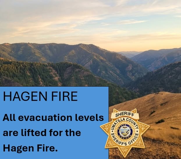
As of Sep 16, 2026, 12:15 PM MDT: All evacuation levels associated with the Hagen Fire have been lifted, effective 11:00 a.m. that day, marking a significant milestone as fire conditions continue to improve.

  • Effective 11:00 a.m. September 16, 2026, all remaining Hagen Fire evacuation zones in Umatilla County, Union County, and CTUIR have returned to Normal status and are no longer under any evacuation level. (per Umatilla County Sheriff's Office · Facebook; per Union County Emergency Services · Facebook)
  • The U.S. Forest Service area closure remains in effect. Returning to Normal evacuation status does not mean closed National Forest lands are open to the public. (per Umatilla County Sheriff's Office · Facebook; per Union County Emergency Services · Facebook)
  • Hazards may remain in the burned area, including weakened or falling trees, falling rocks, pockets of remaining heat, unstable terrain, and firefighters or heavy equipment. (per Umatilla County Sheriff's Office · Facebook; per Union County Emergency Services · Facebook)
  • Removal of an evacuation level does not automatically lift separate road, land-management, or area closures. (per Umatilla County Sheriff's Office · Facebook; per Union County Emergency Services · Facebook)
  • Routine evacuation-level updates for the Hagen Fire will conclude now that all zones have returned to Normal. Updates will be provided if conditions change or additional public safety information is needed. (per Union County Emergency Services · Facebook)
  • Emergency alerts can be signed up for at www.oralert.gov. (per Union County Emergency Services · Facebook)

🤖 AI summary of official posts; may lag or contain errors — verify with the source and official channels. ⚠️ Not an official evacuation order — follow your sheriff/emergency management.

InciWeb·

ORUMF Hagen Fire: Last updated: 2026-09-16 --- The type of incident is Wildfire and involves the following unit(s) Umatilla National Forest. --- State: Oregon --- Coordinates: Latitude: 45° 42 25 Longitude: 118° 16 8 -...

InciWeb·

ORUMF Hagen Fire: Last updated: 2026-09-15 --- The type of incident is Wildfire and involves the following unit(s) Umatilla National Forest. --- State: Oregon --- Coordinates: Latitude: 45° 42 25 Longitude: 118° 16 8 -...

WFIGS·

Containment updated from 82% to 87%.

InciWeb·

ORUMF Hagen Fire: Last updated: 2026-09-14 --- The type of incident is Wildfire and involves the following unit(s) Umatilla National Forest. --- State: Oregon --- Coordinates: Latitude: 45° 42 25 Longitude: 118° 16 8 -...

WFIGS·

Acreage updated from 61,386 to 61,381 acres. Containment updated from 70% to 82%.

InciWeb·

ORUMF Hagen Fire: Last updated: 2026-09-13 --- The type of incident is Wildfire and involves the following unit(s) Umatilla National Forest. --- State: Oregon --- Coordinates: Latitude: 45° 42 25 Longitude: 118° 16 8 -...

WFIGS·

Acreage updated from 61,385 to 61,386 acres. Containment updated from 66% to 70%.

InciWeb·

ORUMF Hagen Fire: Last updated: 2026-09-12 --- The type of incident is Wildfire and involves the following unit(s) Umatilla National Forest. --- State: Oregon --- Coordinates: Latitude: 45° 42 25 Longitude: 118° 16 8 -...

WFIGS·

Containment updated from 63% to 66%.
· AI Discovery

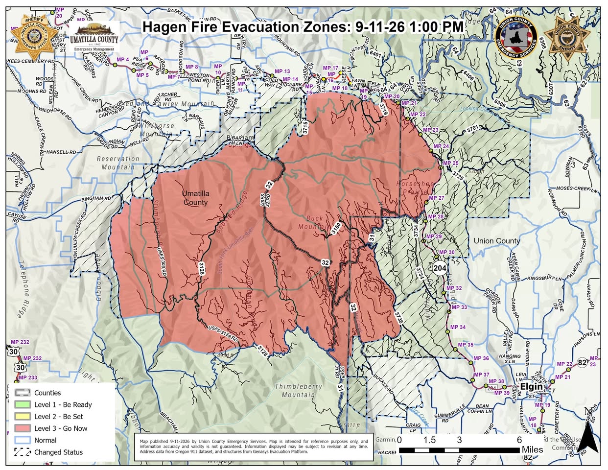
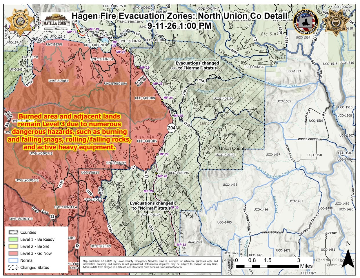
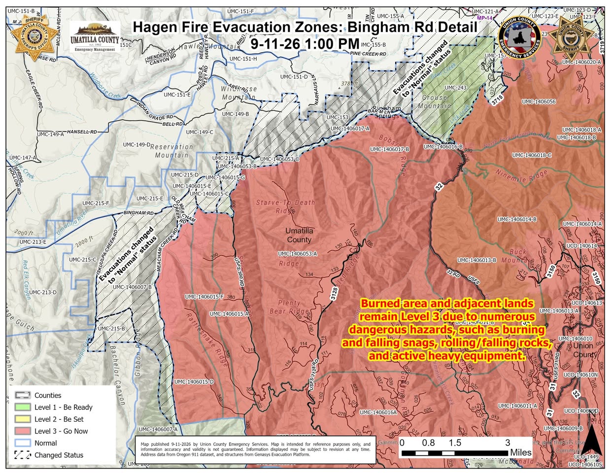
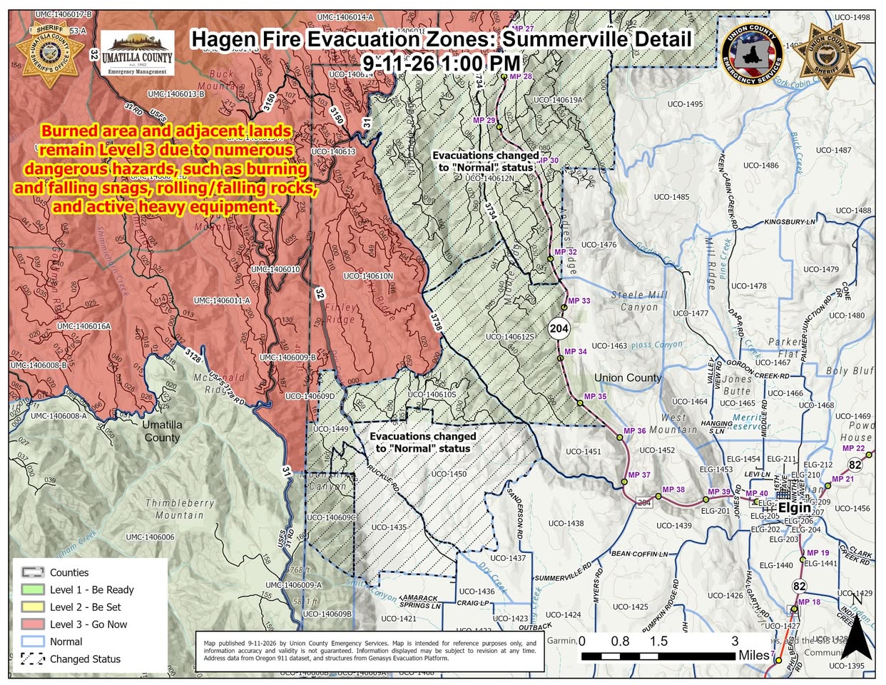
As of Sep 11, 2026, 2:49 PM MDT: The Hagen Fire continues to make progress, allowing emergency officials to lift evacuation levels in additional areas across Umatilla County, Union County, and the Confederated Tribes of the Umatilla Indian Reservation (CTUIR), effective 1:00 p.m. today. Level 3 (GO NOW) evacuations remain in place for the burned area and adjacent lands.

  • Size and containment: The Hagen Fire is currently estimated at 61,815 acres and 64% contained. (per Umatilla County Sheriff's Office · Facebook and Union County Emergency Services · Facebook)
  • Firefighter activity: Firefighters continue to patrol and mop up the fire area, address remaining pockets of heat, complete suppression repair, and protect structures and critical infrastructure. (per Umatilla County Sheriff's Office · Facebook)
  • Evacuation levels lifted — Umatilla County and CTUIR: 16 zones are returning to Normal status, including areas in the Highway 204/Tollgate area (Cold Springs, Tollgate, Bear Creek, Lick Creek, Grouse Mountain, Bingham Springs) and the Bingham Road/Umatilla River corridor extending east toward the Old Meacham Creek Road area. (per Umatilla County Sheriff's Office · Facebook)
  • Evacuation levels lifted — Union County: 12 zones are returning to Normal status, including areas along the Highway 204/Lookingglass corridor (Lookingglass Creek, Eagle Creek) and areas north and northwest of Summerville (Ruckle Road, Sanderson Road). (per Union County Emergency Services · Facebook)
  • Level 3 evacuations remain: The burned area and adjacent lands identified on the evacuation maps remain at Level 3 (GO NOW). (per Umatilla County Sheriff's Office · Facebook)
  • Forest closure remains in effect: The U.S. Forest Service area closure remains in effect. Returning to Normal evacuation status does not mean closed National Forest lands are open for public access. (per Umatilla County Sheriff's Office · Facebook)
  • Hazards warning: Do not rely on visible smoke as an indication that an area is safe. Hazards remain, including burning and falling snags, rolling or falling rocks, pockets of remaining heat, and active heavy equipment. (per Umatilla County Sheriff's Office · Facebook)
  • Emergency alerts: Residents can sign up for emergency alerts at www.oralert.gov. (per Union County Emergency Services · Facebook)

🤖 AI summary of official posts; may lag or contain errors — verify with the source and official channels. ⚠️ Not an official evacuation order — follow your sheriff/emergency management.

InciWeb· First report

First report.

ORUMF Hagen Fire: Last updated: 2026-09-11 --- The type of incident is Wildfire and involves the following unit(s) Umatilla National Forest. --- State: Oregon --- Coordinates: Latitude: 45° 42 25 Longitude: 118° 16 8 -...

Get updates like this the moment they happen.Push alerts for new evacuations, growth & containment changes — free.Follow this fire

Don't refresh this page. Let it find you.

  • Evacuation alerts for your zone — pushed as soon as we see an order, not hours later.
  • Live perimeter & growth — watch the fire move on the map as agencies update it.
  • Draw a zone around home — or anywhere your people are — and get the lead time to act.

Free · iPhone & iPad · Official + local sources · Start as a guest, no account needed

Example alerts

Data from official wildfire feeds and local agencies, refreshed regularly but not guaranteed real-time. Always follow official evacuation orders from local authorities.

Hagen FireSignificant · 61,382 ac · 87% containedFollow