Significant incidentUpdated

Active Wildfire · Wallowa County, OR

Paradise Firenear Wallowa County, OR

Opens in the app — start as a guest, no account needed

86%
Contained
Size
9,656acres
Status
Active
Discovered

From the ground

Latest photos from the fire

6 images · gathered by AI Discovery from official & local sources

Photos are gathered from official agency and local social sources and shown with attribution. Always follow official evacuation orders.

Live in the appThe perimeter updates as agencies publish it.Open live map →
Current fire perimeter9,656 acres · updated

Updates

WFIGS·

Personnel updated to 6.

· AI Discovery

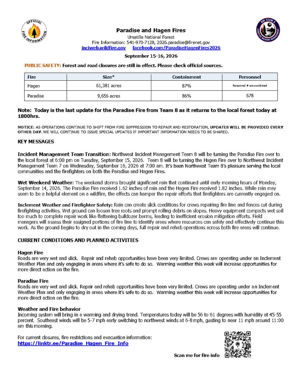
As of Sep 15, 2026, 10:10 AM MDT: The Paradise Fire is 86% contained at 9,656 acres, with management transitioning back to the local forest today. Recent rainfall has slowed repair and rehabilitation efforts, though warming weather this week is expected to allow fuller operations to resume.

  • Size: 9,656 acres (per Umatilla County Sheriff's Office · Facebook)
  • Containment: 86% (per Umatilla County Sheriff's Office · Facebook)
  • Personnel: 678 (shared across both the Paradise and Hagen fires) (per Umatilla County Sheriff's Office · Facebook)
  • Northwest Incident Management Team 8 is turning the Paradise Fire over to the local forest at 6:00 PM on Tuesday, September 15, 2026 (per Umatilla County Sheriff's Office · Facebook)
  • The Paradise Fire received 1.62 inches of rain over the weekend, with rain continuing through early morning hours of September 14, 2026 (per Umatilla County Sheriff's Office · Facebook)
  • Roads are very wet and slick; repair and rehab opportunities have been very limited; crews are operating under an Inclement Weather Plan and only engaging in areas where it is safe to do so (per Umatilla County Sheriff's Office · Facebook)
  • Forest and road closures are still in effect (per Umatilla County Sheriff's Office · Facebook)
  • Today's temperatures: 56 to 61 degrees; humidity: 45–55 percent; southeast winds 5–7 mph early, switching to northwest winds at 6–8 mph, gusting to near 11 mph around 11:00 AM (per Umatilla County Sheriff's Office · Facebook)
  • Updates will now be provided every other day, with special updates issued if important information needs to be shared (per Umatilla County Sheriff's Office · Facebook)
  • Fire information phone: 541-970-7128; email: 2026.paradise@firenet.gov (per Umatilla County Sheriff's Office · Facebook)

🤖 AI summary of official posts; may lag or contain errors — verify with the source and official channels. ⚠️ Not an official evacuation order — follow your sheriff/emergency management.
· AI Discovery

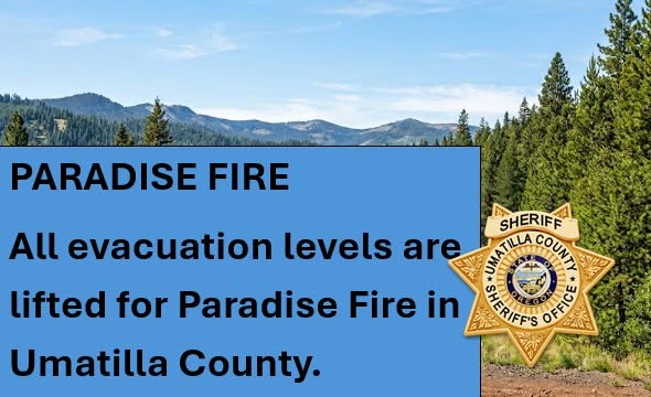
As of Sep 14, 2026, 1:08 PM MDT: All remaining evacuation levels in Umatilla County associated with the Paradise Fire have been lifted, effective 11:00 a.m. today. The change follows continued improvement in fire conditions and significant recent rainfall.

  • Effective 11:00 a.m. September 14, 2026, six remaining Umatilla County evacuation zones — UMC-032, UMC-036, UMC-039, UMC-041, UMC-1406043-C, and UMC-1406043-D — returned to Normal status (per Umatilla County Sheriff's Office · Facebook).
  • There are now no remaining Paradise Fire evacuation levels in Umatilla County (per Umatilla County Sheriff's Office · Facebook).
  • The Paradise Fire area received more than 1.5 inches of rain during the past 48 hours, further improving conditions across the fire area (per Umatilla County Sheriff's Office · Facebook).
  • These changes apply to the Paradise Fire only and do not affect evacuation levels associated with the Hagen Fire (per Umatilla County Sheriff's Office · Facebook).

🤖 AI summary of official posts; may lag or contain errors — verify with the source and official channels. ⚠️ Not an official evacuation order — follow your sheriff/emergency management.
· AI Discovery

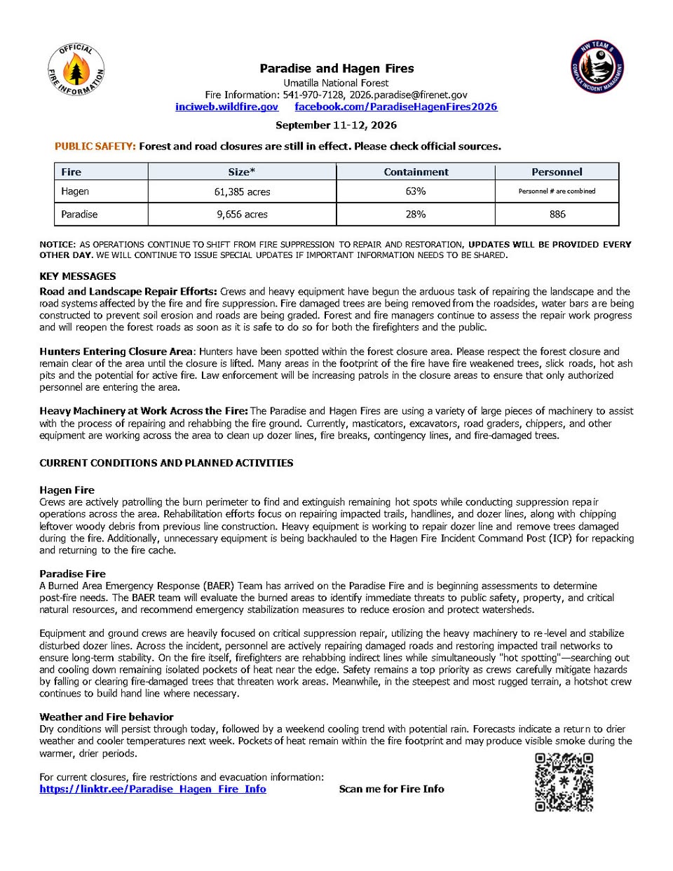
As of Sep 11, 2026, 11:15 AM MDT: The Paradise Fire in Umatilla County is 9,656 acres with 28% containment, as operations shift from active suppression toward repair and rehabilitation. A Burned Area Emergency Response (BAER) Team has arrived and is beginning post-fire assessments.

  • Size: 9,656 acres (per Umatilla County Sheriff's Office · Facebook)
  • Containment: 28% (per Umatilla County Sheriff's Office · Facebook)
  • Personnel: 886, shared across both the Paradise and Hagen fires combined (per Umatilla County Sheriff's Office · Facebook)
  • A BAER Team has arrived on the Paradise Fire and is beginning assessments to identify immediate threats to public safety, property, and critical natural resources, and to recommend emergency stabilization measures to reduce erosion and protect watersheds (per Umatilla County Sheriff's Office · Facebook)
  • Equipment and ground crews are focused on suppression repair, re-leveling and stabilizing disturbed dozer lines, repairing damaged roads, and restoring impacted trail networks (per Umatilla County Sheriff's Office · Facebook)
  • Firefighters are rehabbing indirect lines and hot spotting — searching out and cooling isolated pockets of heat near the fire's edge (per Umatilla County Sheriff's Office · Facebook)
  • A hotshot crew continues to build hand line in the steepest and most rugged terrain (per Umatilla County Sheriff's Office · Facebook)
  • Forest and road closures remain in effect; hunters have been spotted within the closure area and law enforcement is increasing patrols (per Umatilla County Sheriff's Office · Facebook)
  • Dry conditions are expected to persist through today, followed by a weekend cooling trend with potential rain, then a return to drier and cooler weather next week; pockets of heat within the fire footprint may produce visible smoke during warmer, drier periods (per Umatilla County Sheriff's Office · Facebook)
  • Updates will now be issued every other day, with special updates if important information needs to be shared (per Umatilla County Sheriff's Office · Facebook)
  • Fire information phone: 541-970-7128 | Email: 2026.paradise@firenet.gov | InciWeb: www.InciWeb.gov (per Umatilla County Sheriff's Office · Facebook)

🤖 AI summary of official posts; may lag or contain errors — verify with the source and official channels. ⚠️ Not an official evacuation order — follow your sheriff/emergency management.
· AI Discovery

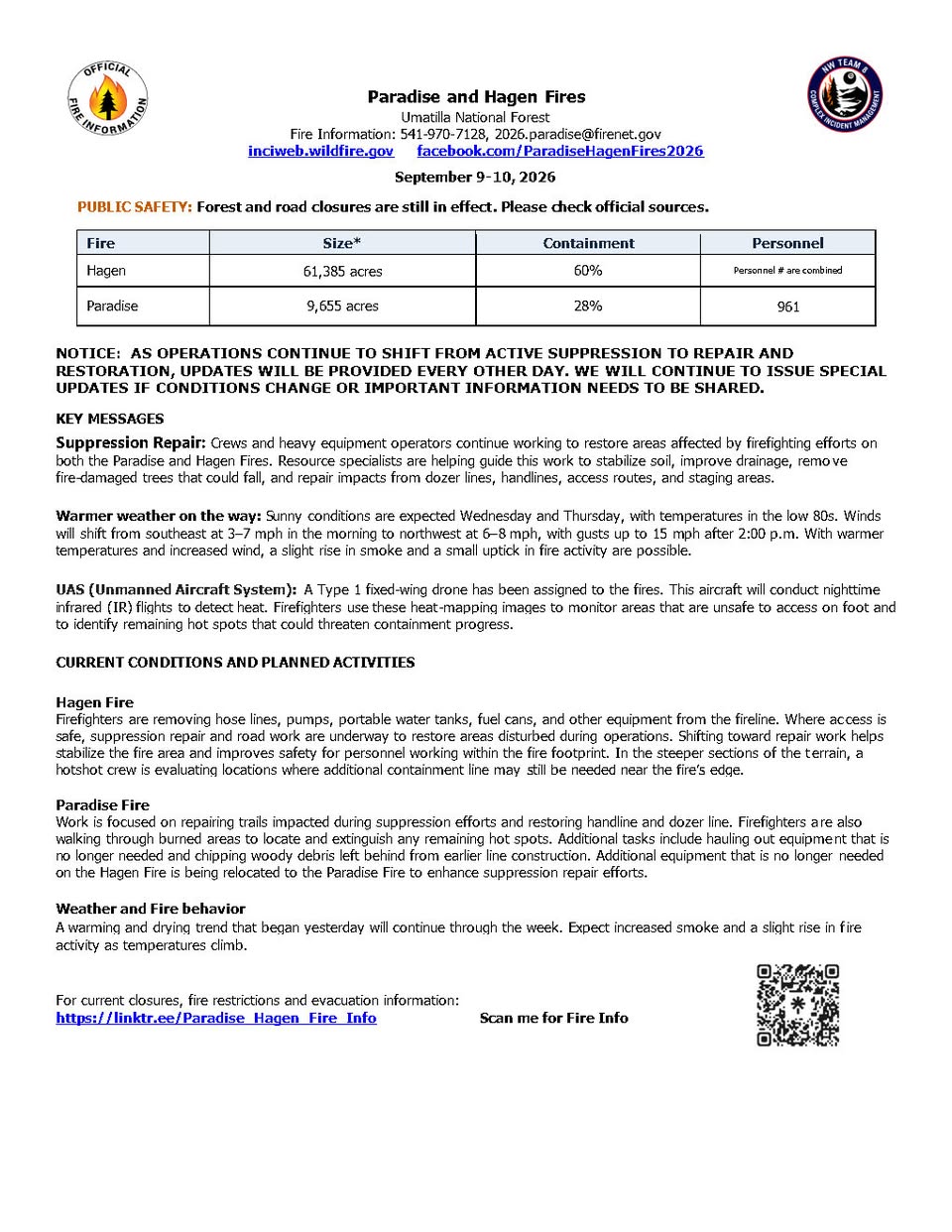
As of Sep 9, 2026, 9:19 AM MDT: The Paradise Fire is burning in the area covered by Umatilla County Sheriff's Office, with operations shifting from active suppression toward repair and restoration. A warming and drying trend is expected to bring a slight rise in fire activity through the week.

  • Size: 9,655 acres (per Umatilla County Sheriff's Office · Facebook)
  • Containment: 28% (per Umatilla County Sheriff's Office · Facebook)
  • Personnel: 961, shared across both the Paradise and Hagen Fires (per Umatilla County Sheriff's Office · Facebook)
  • Crews are repairing trails, handlines, and dozer lines impacted during suppression, and walking burned areas to locate and extinguish remaining hot spots (per Umatilla County Sheriff's Office · Facebook)
  • Equipment no longer needed on the Hagen Fire is being relocated to the Paradise Fire to support suppression repair efforts (per Umatilla County Sheriff's Office · Facebook)
  • A Type 1 fixed-wing drone has been assigned to conduct nighttime infrared flights to detect heat and monitor hot spots (per Umatilla County Sheriff's Office · Facebook)
  • Sunny conditions expected Wednesday and Thursday with temperatures in the low 80s; winds shifting from southeast at 3–7 mph in the morning to northwest at 6–8 mph with gusts up to 15 mph after 2:00 p.m. (per Umatilla County Sheriff's Office · Facebook)
  • Forest and road closures remain in effect; the public is directed to check official sources (per Umatilla County Sheriff's Office · Facebook)
  • Updates will now be issued every other day, with special updates if conditions change (per Umatilla County Sheriff's Office · Facebook)
  • Fire information phone: 541-970-7128 | Email: 2026.paradise@firenet.gov | InciWeb: www.InciWeb.gov (per Umatilla County Sheriff's Office · Facebook)

🤖 AI summary of official posts; may lag or contain errors — verify with the source and official channels. ⚠️ Not an official evacuation order — follow your sheriff/emergency management.
· AI Discovery

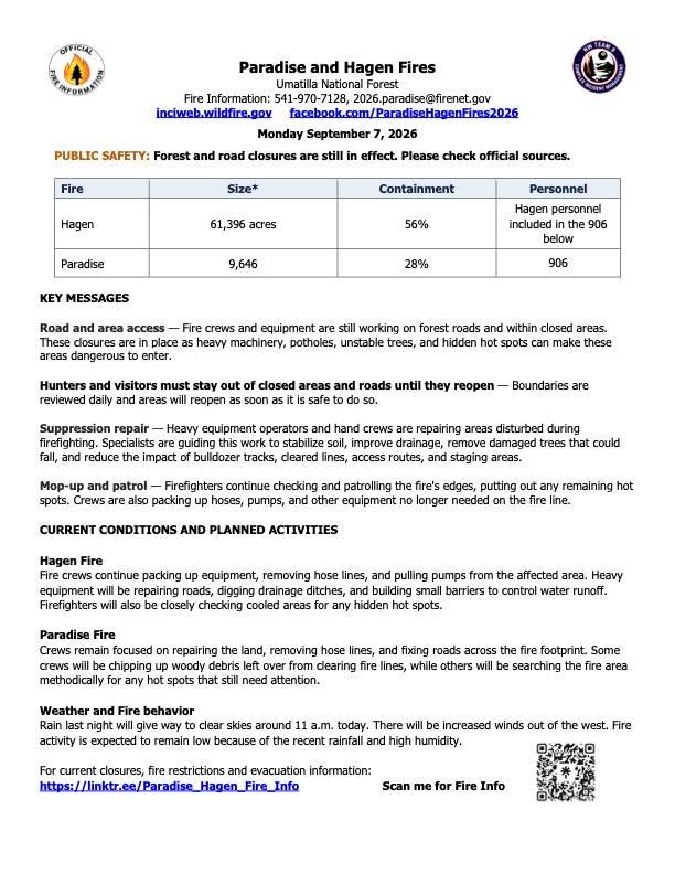
As of Sep 7, 2026, 10:57 AM MDT: The Paradise Fire in the Walla Walla County area has grown to 9,646 acres and is 28% contained, with crews focused on mop-up, suppression repair, and land stabilization. Fire activity is expected to remain low following recent rainfall and high humidity.

  • Size: 9,646 acres (per Walla Walla County Emergency Management · Facebook)
  • Containment: 28% (per Walla Walla County Emergency Management · Facebook)
  • Personnel: 906, which also includes personnel assigned to the nearby Hagen Fire (per Walla Walla County Emergency Management · Facebook)
  • Forest and road closures remain in effect; hunters and visitors must stay out of closed areas until they reopen (per Walla Walla County Emergency Management · Facebook)
  • Crews are repairing land disturbed during firefighting, removing hose lines, fixing roads, chipping woody debris, and searching for remaining hot spots (per Walla Walla County Emergency Management · Facebook)
  • Weather: Rain overnight is giving way to clear skies around 11 a.m., with increased winds out of the west expected; fire activity is expected to remain low due to recent rainfall and high humidity (per Walla Walla County Emergency Management · Facebook)
  • Fire information phone: 541-970-7128; email: 2026.paradise@firenet.gov; current closures and evacuation information: https://linktr.ee/Paradise_Hagen_Fire_Info (per Walla Walla County Emergency Management · Facebook)

🤖 AI summary of official posts; may lag or contain errors — verify with the source and official channels. ⚠️ Not an official evacuation order — follow your sheriff/emergency management.
· AI Discovery

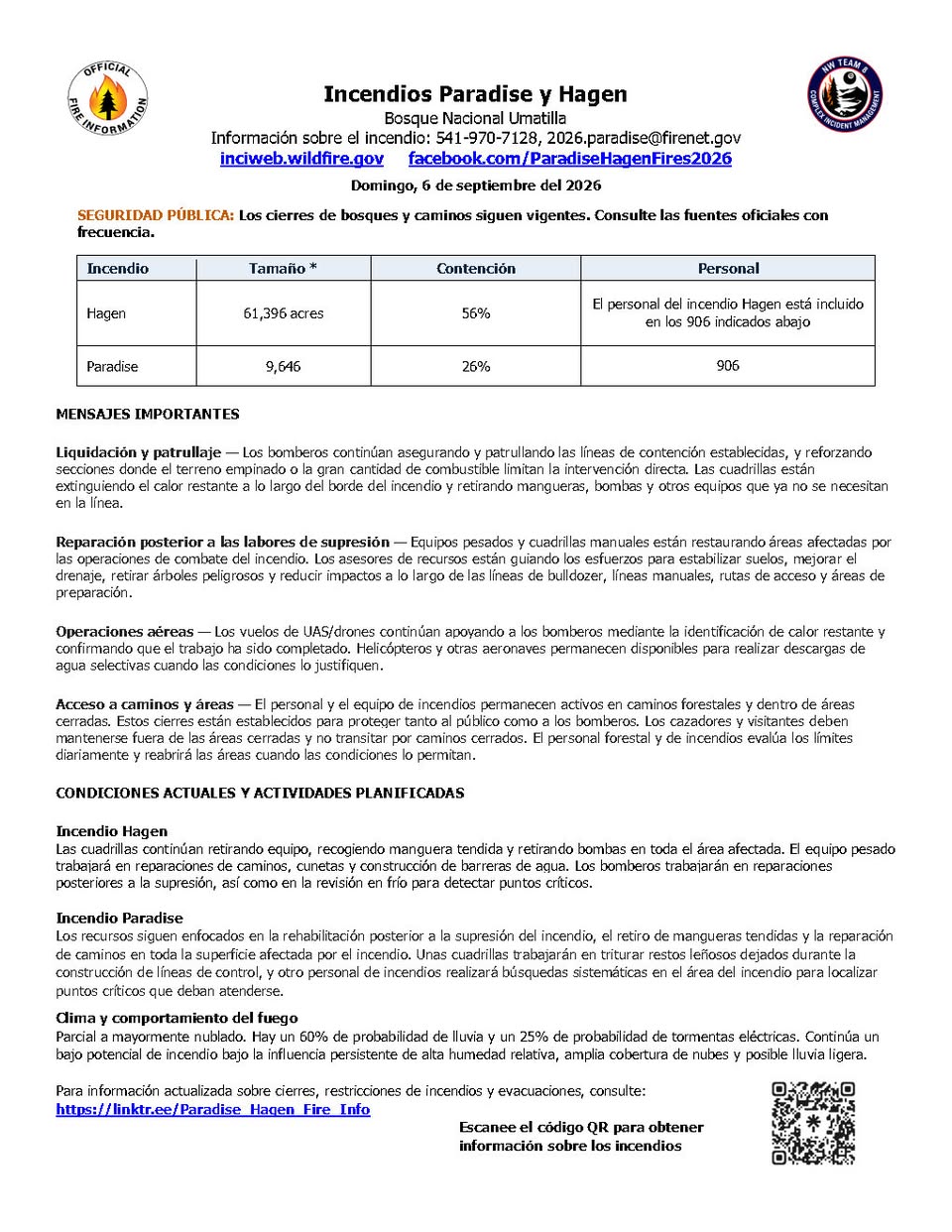
As of Sep 6, 2026, 9:41 AM MDT: The Paradise Fire has reached 9,646 acres and is 26% contained, with firefighting efforts now focused on mop-up, suppression repair, and hot spot detection. Forest and road closures remain in effect.

  • Size: 9,646 acres (per Walla Walla County Emergency Management · Facebook)
  • Containment: 26% (per Walla Walla County Emergency Management · Facebook)
  • Personnel: 906, shared with the Hagen Fire (per Walla Walla County Emergency Management · Facebook)
  • Current operations: Resources are focused on fire suppression rehab, removing hose lays, road repair, chipping woody debris left behind during fire line construction, and gridding the fire in search of hot spots (per Walla Walla County Emergency Management · Facebook)
  • Mop-up and patrol: Firefighters are securing and patrolling established containment lines, extinguishing remaining heat along the fire's edge, and backhauling hose, pumps, and other equipment (per Walla Walla County Emergency Management · Facebook)
  • Aviation: UAS (drone) flights continue to identify remaining heat and confirm completed work; helicopters and other aircraft remain available for targeted water delivery (per Walla Walla County Emergency Management · Facebook)
  • Weather: Partly cloudy to mostly cloudy, with a 60% chance of rain and a 25% chance of thunderstorms; continued low fire potential under high relative humidity, high cloud cover, and possible light rain (per Walla Walla County Emergency Management · Facebook)
  • Road and area closures remain in effect; hunters and visitors must stay out of closed areas and off closed roads (per Walla Walla County Emergency Management · Facebook)
  • Fire information phone: 541-970-7128; current closure and evacuation details: https://linktr.ee/Paradise_Hagen_Fire_Info (per Walla Walla County Emergency Management · Facebook)

🤖 AI summary of official posts; may lag or contain errors — verify with the source and official channels. ⚠️ Not an official evacuation order — follow your sheriff/emergency management.
· AI Discovery

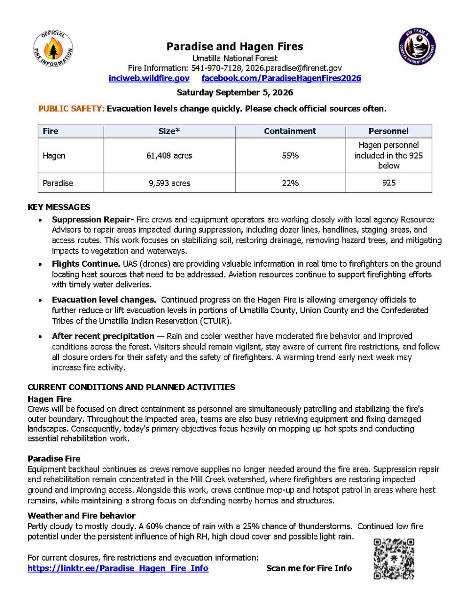
As of Sep 5, 2026, 10:17 AM MDT: The Paradise Fire has burned 9,593 acres and is 22% contained, with crews focused on mop-up, hotspot patrol, and defending nearby homes and structures. Recent rain and cooler weather have moderated fire behavior, though a warming trend early next week may increase fire activity.

  • Size: 9,593 acres (per Walla Walla County Emergency Management · Facebook)
  • Containment: 22% (per Walla Walla County Emergency Management · Facebook)
  • Personnel: 925, shared with the Hagen Fire (per Walla Walla County Emergency Management · Facebook)
  • Suppression repair and rehabilitation are concentrated in the Mill Creek watershed, where firefighters are restoring impacted ground and improving access (per Walla Walla County Emergency Management · Facebook)
  • Equipment backhaul is ongoing as crews remove supplies no longer needed around the fire area (per Walla Walla County Emergency Management · Facebook)
  • UAS (drones) are providing real-time information to firefighters on the ground, locating heat sources; aviation resources continue supporting firefighting efforts with water deliveries (per Walla Walla County Emergency Management · Facebook)
  • Weather: partly cloudy to mostly cloudy, with a 60% chance of rain and a 25% chance of thunderstorms; continued low fire potential under high relative humidity, high cloud cover, and possible light rain (per Walla Walla County Emergency Management · Facebook)
  • Fire information phone: 541-970-7128; email: 2026.paradise@firenet.gov; InciWeb: www.InciWeb.gov; AirNow: fire.airnow.gov (per Walla Walla County Emergency Management · Facebook)

🤖 AI summary of official posts; may lag or contain errors — verify with the source and official channels. ⚠️ Not an official evacuation order — follow your sheriff/emergency management.
· AI Discovery

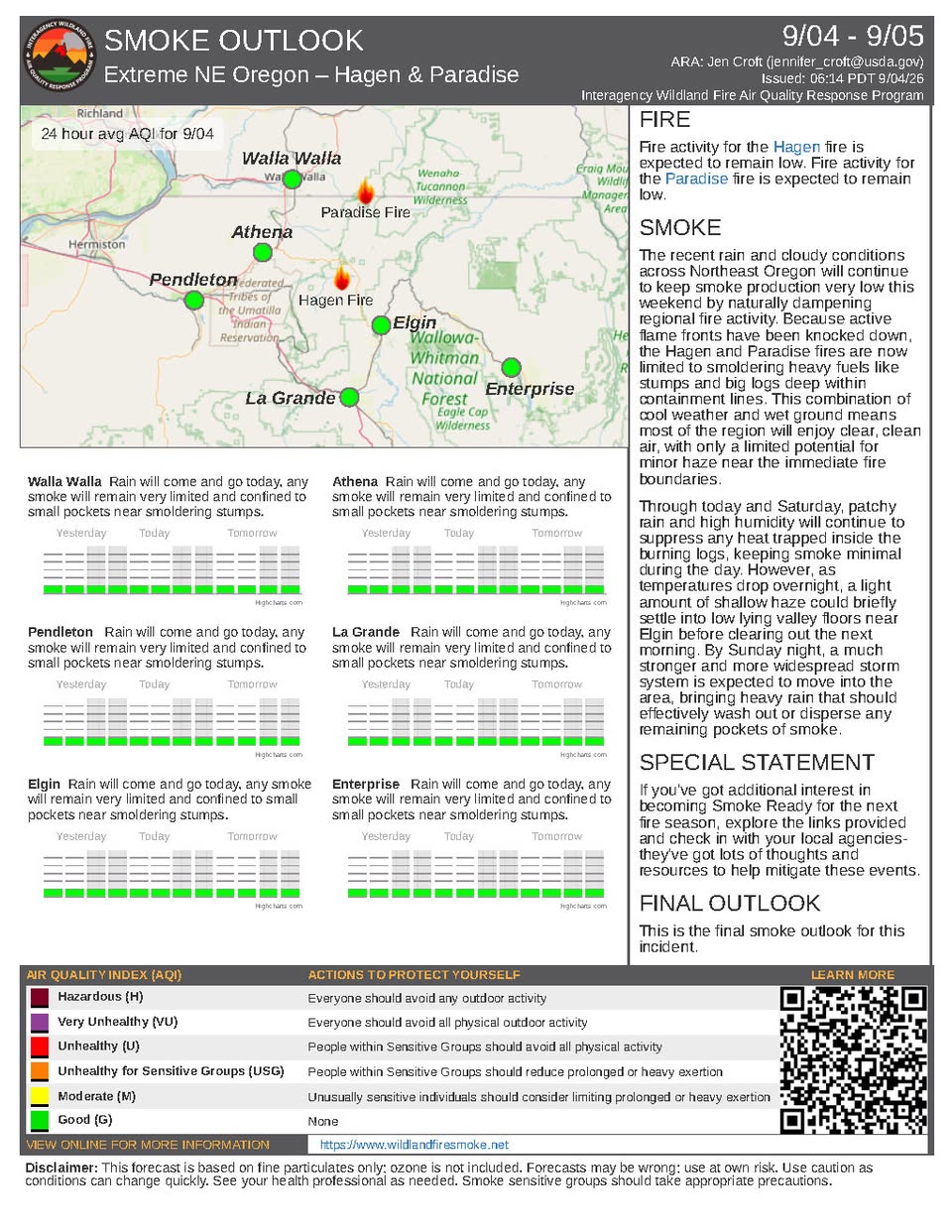
As of Sep 4, 2026, 11:26 AM MDT: The Paradise Fire is burning at 9,634 acres with 22% containment, as firefighters focus on structure protection and suppression repair while the fire remains active in some areas. Changing temperatures and rain are helping moderate fire behavior, though heavy fuels continue to smolder.

  • Size: 9,634 acres (per Walla Walla County Emergency Management · Facebook)
  • Containment: 22% (per Walla Walla County Emergency Management · Facebook)
  • Personnel assigned: 293 (per Walla Walla County Emergency Management · Facebook)
  • Firefighters are focused on structure protection on portions of the fire and scouting for opportunities to increase containment where the fire remains active (per Walla Walla County Emergency Management · Facebook)
  • The Mill Creek watershed is a focal point for suppression repair work; back hauling of equipment is active across many locations on the fire (per Walla Walla County Emergency Management · Facebook)
  • A Heavy Equipment Group is being formed to perform repair and rehab work; assessments are underway to determine equipment needs (per Walla Walla County Emergency Management · Facebook)
  • Rain has helped moderate fire behavior, but heavy fuels will continue to smolder (per Walla Walla County Emergency Management · Facebook)
  • Rain and thunderstorms remain possible for the next few days, with temperatures expected to remain in the high 50s to low 60s (per Walla Walla County Emergency Management · Facebook)
  • Motorists are reminded to drive defensively due to high animal activity early morning and late evening (per Walla Walla County Emergency Management · Facebook)
  • Fire information phone: 541-970-7128; email: 2026.paradise@firenet.gov; updates at InciWeb (www.InciWeb.gov) (per Walla Walla County Emergency Management · Facebook)

🤖 AI summary of official posts; may lag or contain errors — verify with the source and official channels. ⚠️ Not an official evacuation order — follow your sheriff/emergency management.
· AI Discovery

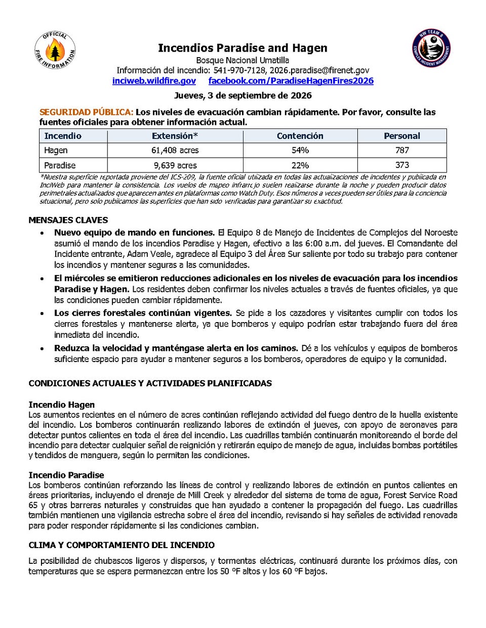
As of Sep 3, 2026, 10:33 AM MDT: The Paradise Fire is burning at 9,639 acres with 22% containment, with firefighters focused on reinforcing control lines and mopping up hotspots. A new command team took over this morning and evacuation levels have seen additional reductions.

  • Size: 9,639 acres (per Walla Walla County Emergency Management · Facebook)
  • Containment: 22% (per Walla Walla County Emergency Management · Facebook)
  • Personnel assigned: 373 (per Walla Walla County Emergency Management · Facebook)
  • Command change: Northwest Complex Incident Management Team 8 took command of the Paradise Fire effective 6:00 AM Thursday, with Incident Commander Adam Veale leading. The outgoing Southern Area Team 3 was thanked for their work. (per Walla Walla County Emergency Management · Facebook)
  • Firefighter activities: Crews are reinforcing control lines and mopping up hotspots in priority areas including the Mill Creek drainage, around the water intake system, Forest Service Road 65, and other natural and constructed barriers. Crews are also monitoring for signs of renewed activity. (per Walla Walla County Emergency Management · Facebook)
  • Evacuations: Additional reductions to evacuation levels were issued on Wednesday. Residents should confirm current levels through official sources, as conditions can change quickly. Current evacuation information is available through Umatilla County Sheriff's Office, Union County Sheriff's Office, and the Confederated Tribes of the Umatilla Indian Reservation. (per Walla Walla County Emergency Management · Facebook)
  • Closures: The Umatilla National Forest has issued closures for public safety and to support firefighting operations. A Paradise Fire Emergency Closure is in effect. Forest closures remain in place; hunters and visitors are asked to comply. (per Walla Walla County Emergency Management · Facebook)
  • Fire restrictions: The Umatilla National Forest has issued public use restrictions for smoking, off-road travel, and chainsaw use across the entire national forest. (per Walla Walla County Emergency Management · Facebook)
  • Weather: Light, patchy showers and thunderstorms are possible for the next few days, with temperatures expected in the high 50s to low 60s. Rain may help moderate fire behavior, though heavy fuels will continue to smolder. Gusty winds or lightning could produce new localized activity. (per Walla Walla County Emergency Management · Facebook)
  • Drones: Any drone near the fire grounds aircraft until the area is confirmed clear. (per Walla Walla County Emergency Management · Facebook)
  • Fire information contact: 541-970-7128 or 2026.paradise@firenet.gov (per Walla Walla County Emergency Management · Facebook)

🤖 AI summary of official posts; may lag or contain errors — verify with the source and official channels. ⚠️ Not an official evacuation order — follow your sheriff/emergency management.
· AI Discovery

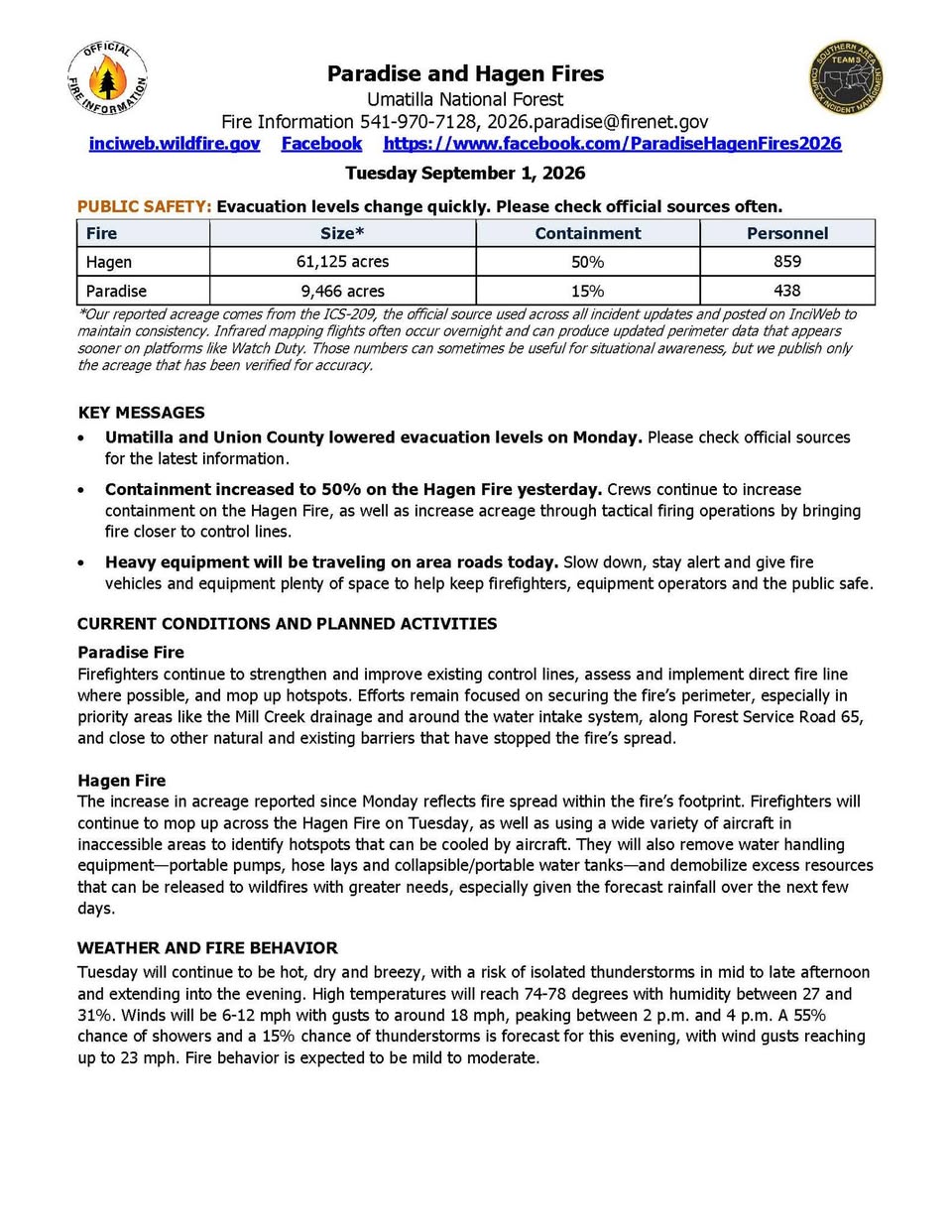
As of Sep 1, 2026, 9:59 AM MDT: The Paradise Fire is burning at 9,466 acres with 15% containment, with firefighters focused on securing and mopping up firelines in key areas. No tactical burning is planned for the Paradise Fire today.

  • Size: 9,466 acres (per Walla Walla County Emergency Management · Facebook)
  • Containment: 15% (per Walla Walla County Emergency Management · Facebook)
  • Personnel assigned: 438 (per Walla Walla County Emergency Management · Facebook)
  • Firefighters are continuing to secure and mop up firelines along the Mill Creek drainage and near the intake, near Forest Service Road 65, and along other existing control lines (per Walla Walla County Emergency Management · Facebook)
  • No tactical burning is planned for the Paradise Fire today (per Walla Walla County Emergency Management · Facebook)
  • Oregon National Guard aviation resources were released from the Paradise Fire yesterday (per Walla Walla County Emergency Management · Facebook)
  • Personnel from Australia and New Zealand joined firefighting efforts on the Paradise Fire yesterday (per Walla Walla County Emergency Management · Facebook)
  • A Paradise Fire Emergency Closure is in effect on the Umatilla National Forest; full details at the U.S. Forest Service website (per Walla Walla County Emergency Management · Facebook)
  • Evacuation levels are managed by the Umatilla County Sheriff's Office, Union County Sheriff's Office, and the Confederated Tribes of the Umatilla Indian Reservation — check respective county emergency management websites for current levels (per Walla Walla County Emergency Management · Facebook)
  • Weather: temperatures expected to reach the low-to-mid 70s, relative humidity 26–30%, winds 5–10 mph in the morning with afternoon gusts up to 15–18 mph; modest fire activity is expected (per Walla Walla County Emergency Management · Facebook)
  • Fire information phone: 541-970-7128; email: 2026.paradise@firenet.gov (per Walla Walla County Emergency Management · Facebook)

🤖 AI summary of official posts; may lag or contain errors — verify with the source and official channels. ⚠️ Not an official evacuation order — follow your sheriff/emergency management.
· AI Discovery

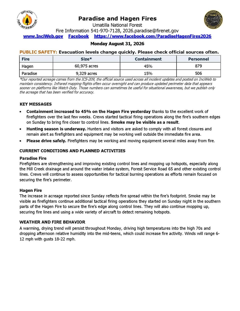
As of Aug 31, 2026, 10:58 AM MDT: The Paradise Fire has burned 9,329 acres and is 15% contained, with firefighters focused on securing and mopping up firelines. Modest fire activity is expected today under warm, dry, and breezy conditions.

  • Size: 9,329 acres (per Walla Walla County Emergency Management · Facebook; per Columbia County WA E-911 and Emergency Management · Facebook)
  • Containment: 15% (per Walla Walla County Emergency Management · Facebook; per Columbia County WA E-911 and Emergency Management · Facebook)
  • Personnel assigned: 506 (per Walla Walla County Emergency Management · Facebook; per Columbia County WA E-911 and Emergency Management · Facebook)
  • Firefighters are securing and mopping up firelines, especially along the Mill Creek drainage and close to the intake, near Forest Service Road 65 and next to other existing control lines. Crews are also preparing areas where containment lines can be safely strengthened. (per Walla Walla County Emergency Management · Facebook)
  • No tactical burning is planned for the Paradise Fire today. (per Walla Walla County Emergency Management · Facebook)
  • Oregon National Guard aviation resources were released from the Paradise Fire yesterday. (per Walla Walla County Emergency Management · Facebook)
  • Several individuals from Australia and New Zealand joined firefighting efforts on the Paradise Fire yesterday. (per Walla Walla County Emergency Management · Facebook)
  • Weather: Temperatures expected to climb to the mid to low 70s. Relative humidity 26–30%. Winds 5–10 mph in the morning with afternoon gusts peaking around 15–18 mph. Modest fire activity is expected. (per Walla Walla County Emergency Management · Facebook)
  • A Paradise Fire Emergency Closure is in effect on the Umatilla National Forest. The U.S. Forest Service has also issued public use restrictions for smoking, off-road travel, and chainsaw use across the entire national forest. (per Walla Walla County Emergency Management · Facebook)
  • Evacuation levels are managed by the Umatilla County Sheriff's Office, Union County Sheriff's Office, and the Confederated Tribes of the Umatilla Indian Reservation. Residents should check those agencies directly, as levels are frequently adjusted. (per Walla Walla County Emergency Management · Facebook)
  • Fire information phone: 541-970-7128. Updates also available at InciWeb (www.InciWeb.gov). (per Walla Walla County Emergency Management · Facebook)

🤖 AI summary of official posts; may lag or contain errors — verify with the source and official channels. ⚠️ Not an official evacuation order — follow your sheriff/emergency management.
· AI Discovery

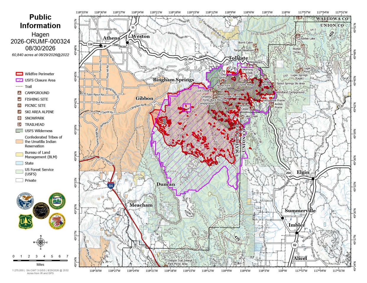
As of Aug 30, 2026, 10:21 AM MDT: The Paradise Fire is burning at 9,324 acres with 15% containment, with firefighters focused on securing and mopping up firelines in key areas. No tactical burning is planned for the Paradise Fire today.

  • Size: 9,324 acres (per Walla Walla County Emergency Management · Facebook)
  • Containment: 15% (per Walla Walla County Emergency Management · Facebook)
  • Personnel assigned: 496 (per Walla Walla County Emergency Management · Facebook)
  • Firefighters are securing and mopping up firelines along the Mill Creek drainage near the intake, near Forest Service Road 65, and along other existing control lines. Crews are also preparing areas where containment lines can be safely strengthened. (per Walla Walla County Emergency Management · Facebook)
  • No tactical burning is planned for the Paradise Fire today. (per Walla Walla County Emergency Management · Facebook)
  • Oregon National Guard aviation resources were released from the Paradise Fire yesterday. (per Walla Walla County Emergency Management · Facebook)
  • Personnel from Australia and New Zealand joined firefighting efforts on the Paradise Fire yesterday. (per Walla Walla County Emergency Management · Facebook)
  • A Paradise Fire Emergency Closure is in effect on the Umatilla National Forest. (per Walla Walla County Emergency Management · Facebook)
  • U.S. Forest Service Umatilla National Forest has issued public use restrictions for smoking, off-road travel, and chainsaw use across the entire national forest. (per Walla Walla County Emergency Management · Facebook)
  • Expected weather: temperatures climbing to the mid to low 70s, relative humidity 26–30%, winds 5–10 mph in the morning with afternoon gusts peaking around 15–18 mph. Modest fire activity is expected. (per Walla Walla County Emergency Management · Facebook)
  • Evacuation levels are managed by the Umatilla County Sheriff's Office, Union County Sheriff's Office, and the Confederated Tribes of the Umatilla Indian Reservation. Residents should check those agencies directly, as evacuation levels and road closures are frequently adjusted. (per Walla Walla County Emergency Management · Facebook)
  • Hunters and visitors are urged to respect all forest closures and remain alert, as firefighters and equipment may be operating miles away from the actual fire perimeter. (per Walla Walla County Emergency Management · Facebook)
  • Fire information phone: 541-970-7128 | Email: 2026.paradise@firenet.gov | InciWeb: www.InciWeb.gov (per Walla Walla County Emergency Management · Facebook)

🤖 AI summary of official posts; may lag or contain errors — verify with the source and official channels. ⚠️ Not an official evacuation order — follow your sheriff/emergency management.
· AI Discovery

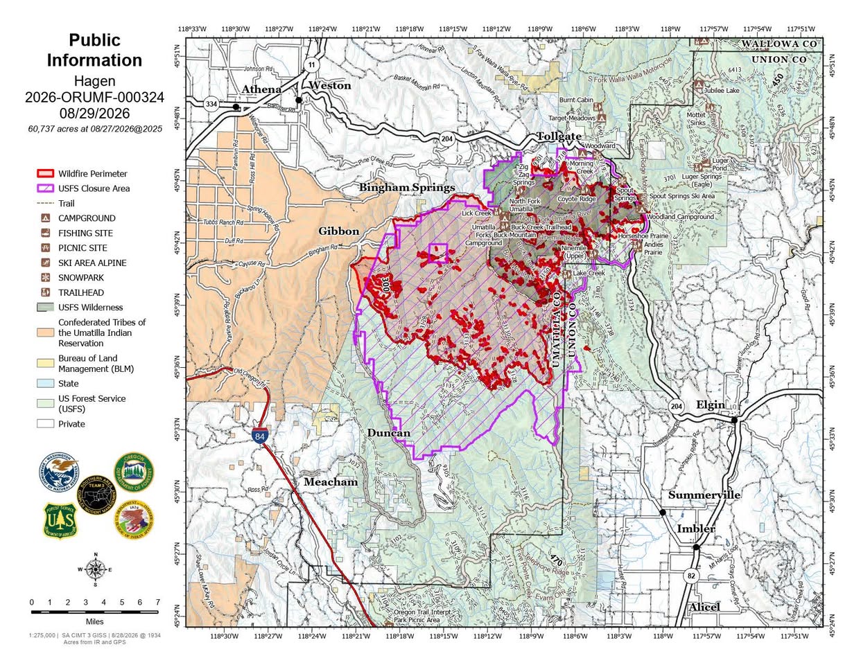
As of Aug 29, 2026, 11:06 AM MDT: The Paradise Fire is burning at 9,324 acres with 15% containment. Firefighters are focused on securing and mopping up firelines, particularly along the Mill Creek drainage and Forest Service Road 65, with no tactical firing operations planned today due to forecast winds.

  • Size: 9,324 acres (per Walla Walla County Emergency Management · Facebook; per Columbia County WA E-911 and Emergency Management · Facebook)
  • Containment: 15% (per Walla Walla County Emergency Management · Facebook; per Columbia County WA E-911 and Emergency Management · Facebook)
  • Personnel assigned: 500 (per Walla Walla County Emergency Management · Facebook; per Columbia County WA E-911 and Emergency Management · Facebook)
  • Reported acreage is drawn from the ICS-209, the official source posted on InciWeb (per Walla Walla County Emergency Management · Facebook)
  • Today's operations: Firefighters will secure and mop up firelines, especially along the critical Mill Creek drainage and around the intake, along Forest Service Road 65 and other existing control lines (per Walla Walla County Emergency Management · Facebook)
  • Crews are patrolling, cooling hot spots, improving access, and preparing areas where containment lines can be safely built and strengthened (per Walla Walla County Emergency Management · Facebook)
  • No tactical firing operations are planned today due to forecast winds (per Walla Walla County Emergency Management · Facebook)
  • Evacuation levels in Umatilla and Union Counties were lowered yesterday; residents should check official sources as conditions can change quickly (per Walla Walla County Emergency Management · Facebook)
  • The Paradise Fire Emergency Closure around the Mill Creek Watershed remains in place (per Walla Walla County Emergency Management · Facebook)
  • The U.S. Forest Service – Umatilla National Forest has issued public use restrictions for smoking, off-road travel, and chainsaw use across the entire national forest (per Walla Walla County Emergency Management · Facebook)
  • Weather: Temperatures trending cooler, reaching the low 60s; relative humidity in the mid-30s; winds starting at 15–17 mph with gusts up to 30 mph late this afternoon into the evening; fire activity could be mixed given low temperatures and high wind gusts later today (per Walla Walla County Emergency Management · Facebook)
  • For current evacuation levels, check the Umatilla County Sheriff's Office, Union County Sheriff's Office, Confederated Tribes of the Umatilla Indian Reservation, and respective county emergency management websites (per Walla Walla County Emergency Management · Facebook)
  • Fire information phone: 541-970-7128; Email: 2026.paradise@firenet.gov; InciWeb: www.InciWeb.gov (per Walla Walla County Emergency Management · Facebook)

🤖 AI summary of official posts; may lag or contain errors — verify with the source and official channels. ⚠️ Not an official evacuation order — follow your sheriff/emergency management.
· AI Discovery

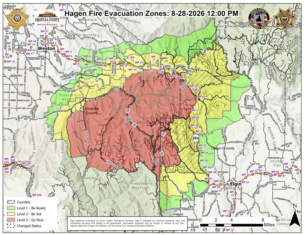
As of Aug 29, 2026, 11:06 AM MDT: The Paradise Fire is burning in the Mill Creek area within the Umatilla National Forest, with firefighters focused on securing and mopping up containment lines amid changing weather conditions including forecast high wind gusts.

  • Size: 9,324 acres (per Umatilla County Sheriff's Office · Facebook)
  • Containment: 15% (per Umatilla County Sheriff's Office · Facebook)
  • Personnel assigned: 500 (per Umatilla County Sheriff's Office · Facebook)
  • Firefighters are securing and mopping up firelines, with priority on the Mill Creek drainage, around the intake, and along Forest Service Road 65 and other existing control lines (per Umatilla County Sheriff's Office · Facebook)
  • The Paradise Fire Emergency Closure around the Mill Creek Watershed remains in place (per Umatilla County Sheriff's Office · Facebook)
  • Umatilla and Union County evacuation levels were lowered yesterday; residents are advised to check official sources as conditions can change quickly (per Umatilla County Sheriff's Office · Facebook)
  • No tactical firing operations are planned today due to forecast winds (per Umatilla County Sheriff's Office · Facebook)
  • Weather: temperatures reaching the low 60s, relative humidity in the mid-30s, winds starting at 15–17 mph with gusts up to 30 mph late this afternoon into the evening (per Umatilla County Sheriff's Office · Facebook)
  • The U.S. Forest Service – Umatilla National Forest has issued public use restrictions for smoking, off-road travel, and chainsaw use across the entire national forest (per Umatilla County Sheriff's Office · Facebook)
  • Fire information phone: 541-970-7128; email: 2026.paradise@firenet.gov (per Umatilla County Sheriff's Office · Facebook)

🤖 AI summary of official posts; may lag or contain errors — verify with the source and official channels. ⚠️ Not an official evacuation order — follow your sheriff/emergency management.
· AI Discovery

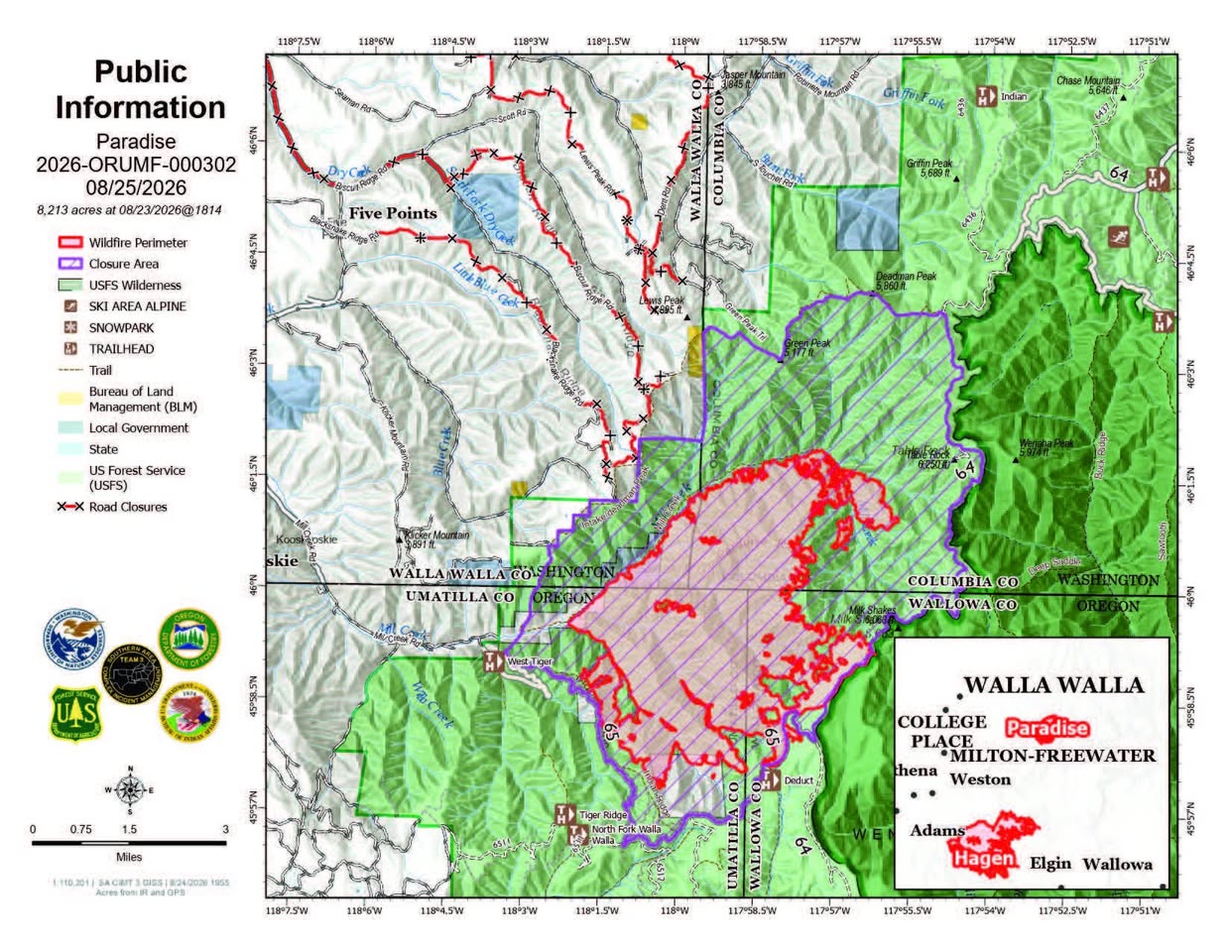
As of Aug 29, 2026, 11:06 AM MDT: The Paradise Fire is burning at 9,324 acres with 15% containment, with firefighters focused on securing and mopping up firelines, particularly along the Mill Creek drainage and Forest Service Road 65.

  • Size: 9,324 acres (per Walla Walla County Emergency Management · Facebook)
  • Containment: 15% (per Walla Walla County Emergency Management · Facebook)
  • Personnel assigned: 500 (per Walla Walla County Emergency Management · Facebook)
  • Firefighters are securing and mopping up firelines, with priority on the Mill Creek drainage and intake area, along Forest Service Road 65 and other existing control lines. Crews are patrolling, cooling hot spots, improving access, and building containment lines. (per Walla Walla County Emergency Management · Facebook)
  • A Paradise Fire Emergency Closure around the Mill Creek Watershed remains in place on the Umatilla National Forest. (per Walla Walla County Emergency Management · Facebook)
  • Umatilla and Union County evacuation levels were lowered yesterday; residents are directed to check official sources for current information. (per Walla Walla County Emergency Management · Facebook)
  • No tactical firing operations are planned today due to forecast winds. (per Walla Walla County Emergency Management · Facebook)
  • Weather: Temperatures reaching the low 60s, relative humidity in the mid-30s, winds starting at 15–17 mph with gusts up to 30 mph expected late afternoon into evening. (per Walla Walla County Emergency Management · Facebook)
  • U.S. Forest Service public use restrictions for smoking, off-road travel, and chainsaw use are in effect across the entire Umatilla National Forest. (per Walla Walla County Emergency Management · Facebook)
  • Fire information phone: 541-970-7128; Email: 2026.paradise@firenet.gov (per Walla Walla County Emergency Management · Facebook)

🤖 AI summary of official posts; may lag or contain errors — verify with the source and official channels. ⚠️ Not an official evacuation order — follow your sheriff/emergency management.
· AI Discovery

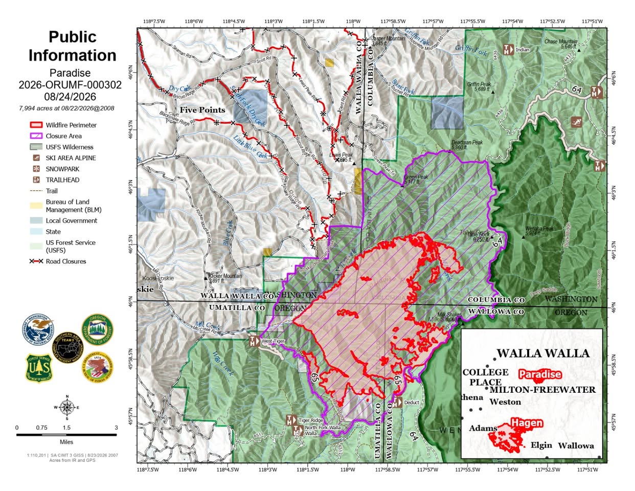
As of Aug 28, 2026, 1:30 PM MDT: The Paradise Fire has reached 9,272 acres with 13% containment, and emergency officials have reduced several evacuation zones from Level 3 (GO NOW) to Level 2 (BE SET) following substantial firefighting progress. All other evacuation areas not listed remain at their current evacuation level.

  • The Paradise Fire is estimated at 9,272 acres with 13% containment and 463 resources assigned. (per Walla Walla County Emergency Management · Facebook and Umatilla County Sheriff's Office · Facebook)
  • Substantial progress was made securing the Mill Creek/Tiger Creek Road intersection and water intake structures in that area. (per Walla Walla County Emergency Management · Facebook and Umatilla County Sheriff's Office · Facebook)
  • Effective immediately, the following Umatilla County evacuation zones have been reduced from Level 3 (GO NOW) to Level 2 (BE SET): UMC-036, UMC-1406043-D, and UMC-1406043-C. This includes the area east of the intersection of Mill Creek Road and Tiger Canyon Road, north to the Washington State Line, and south to include Tiger Canyon Road/NF 65, including the Intake Trail for the Mill Creek Watershed. The area is north of the Mill Creek River corridor and west of the Paradise Fire boundary. (per Walla Walla County Emergency Management · Facebook and Umatilla County Sheriff's Office · Facebook)
  • Firefighters, engines, and heavy equipment will continue working throughout affected areas to strengthen containment features, mop up remaining heat, and protect homes, infrastructure, and other values at risk. (per Walla Walla County Emergency Management · Facebook and Umatilla County Sheriff's Office · Facebook)
  • All applicable U.S. Forest Service road and area closures remain in effect. (per Walla Walla County Emergency Management · Facebook and Umatilla County Sheriff's Office · Facebook)
  • Residents and travelers should expect fire personnel, engines, heavy equipment, and emergency vehicles operating throughout affected areas and are asked to slow down and give crews room to work. (per Walla Walla County Emergency Management · Facebook and Umatilla County Sheriff's Office · Facebook)

🤖 AI summary of official posts; may lag or contain errors — verify with the source and official channels. ⚠️ Not an official evacuation order — follow your sheriff/emergency management.
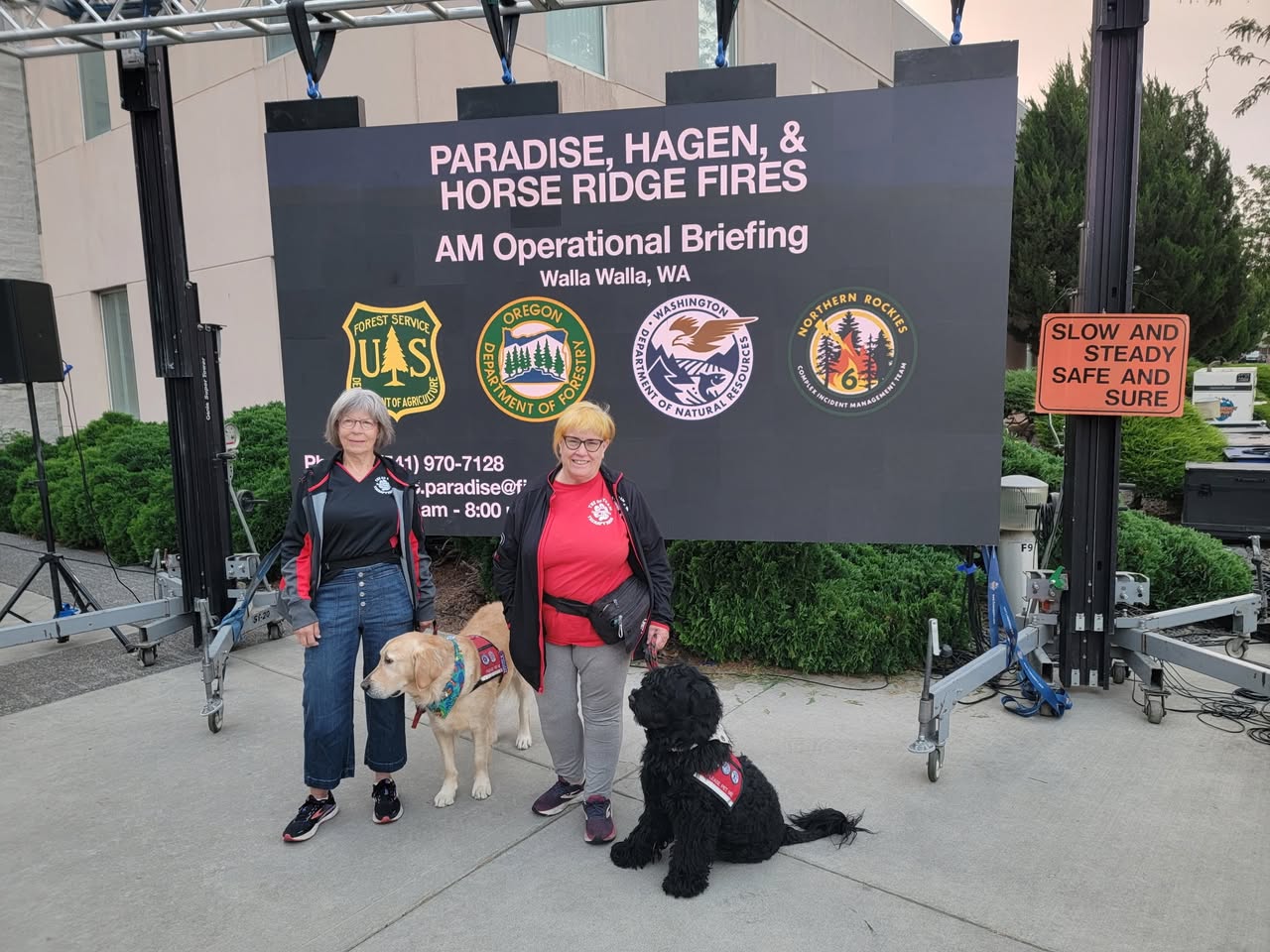
· AI Discovery

As of Aug 28, 2026, 1:30 PM MDT: The Paradise Fire has reached 9,272 acres with 13% containment, and officials have reduced several evacuation zones from Level 3 (GO NOW) to Level 2 (BE SET) following substantial firefighting progress. A proclamation has also been issued allowing Walla Walla city and county to seek federal assistance for water impacts from the fire. Evacuation level reductions (effective immediately, Umatilla County — reduced from Level 3 to Level 2 – BE SET): All other evacuation areas not listed above remain at their current evacuation level (per Umatilla County Sheriff's Office · Facebook). All applicable U.S. Forest Service road and area closures remain in effect (per Umatilla County Sheriff's Office · Facebook). Drivers should slow down and watch for firefighters, engines, and heavy equipment operating throughout affected areas (per Umatilla County Sheriff's Office · Facebook).

  • Size: 9,272 acres (per Umatilla County Sheriff's Office · Facebook)
  • Containment: 13% (per Umatilla County Sheriff's Office · Facebook)
  • Resources assigned: 463 (per Umatilla County Sheriff's Office · Facebook)
  • Progress: Substantial progress was made yesterday securing the Mill Creek/Tiger Creek Road intersection and water intake structures in that area (per Umatilla County Sheriff's Office · Facebook)
  • Federal assistance: The proclamation allows the city and county of Walla Walla to seek federal assistance for impacts to water from the Paradise Fire (per Walla Walla County Emergency Management · Facebook)
  • Zones UMC-036, UMC-1406043-D, and UMC-1406043-C: the area east of the intersection of Mill Creek Road and Tiger Canyon Road, north to the Washington State Line, and south to include Tiger Canyon Road/NF 65, including the Intake Trail for the Mill Creek Watershed; the area is north of the Mill Creek River corridor and west of the Paradise Fire boundary (per Umatilla County Sheriff's Office · Facebook)

🤖 AI summary of official posts; may lag or contain errors — verify with the source and official channels. ⚠️ Not an official evacuation order — follow your sheriff/emergency management.
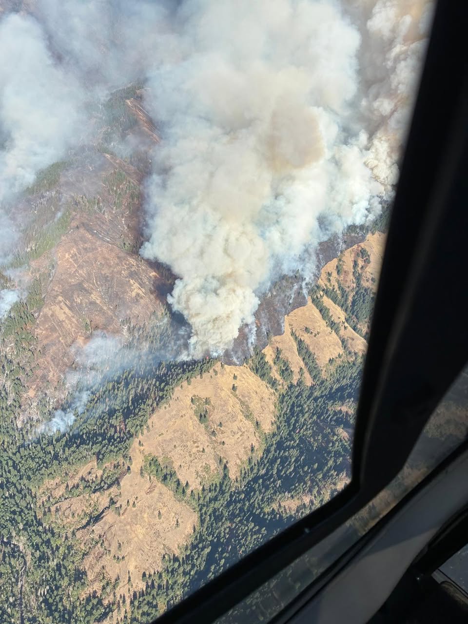
· AI Discovery

As of Aug 25, 2026, 12:24 PM MDT: The Paradise Fire is burning at 8,213 acres with 0% containment, with firefighters conducting strategic firing operations and mop-up work across multiple areas. Smoke is expected to be visible in the Mill Creek area today as a result of these planned operations.

  • Size: 8,213 acres (per Walla Walla County Fire District #4 · Facebook)
  • Containment: 0% (per Walla Walla County Fire District #4 · Facebook)
  • Personnel assigned: 369 (per Walla Walla County Fire District #4 · Facebook)
  • A Paradise Fire Emergency Closure is in effect on the Umatilla National Forest for public safety and to support firefighting operations (per Walla Walla County Fire District #4 · Facebook)
  • The U.S. Forest Service – Umatilla National Forest has issued public use restrictions for smoking, off-road travel, and chainsaw use across the entire national forest (per Walla Walla County Fire District #4 · Facebook)
  • Evacuation levels are managed by the Umatilla County Sheriff's Office, Union County Sheriff's Office, and the Confederated Tribes of the Umatilla Indian Reservation; fire conditions can change rapidly and levels are frequently adjusted (per Walla Walla County Fire District #4 · Facebook)
  • Today's forecast includes highs from the low to mid 80s to near 90 degrees, humidity of 20–22%, southeast winds of 8–18 mph with gusts around 15–20 mph, and a 35% chance of thunderstorms that could produce lightning and sudden outflow winds of 40–45 mph (per Walla Walla County Fire District #4 · Facebook)
  • Fire information phone: 541-970-7128; email: 2026.paradise@firenet.gov (per Walla Walla County Fire District #4 · Facebook)

🤖 AI summary of official posts; may lag or contain errors — verify with the source and official channels. ⚠️ Not an official evacuation order — follow your sheriff/emergency management.
· AI Discovery

As of Aug 25, 2026, 12:24 PM MDT: The Paradise Fire is burning at 8,213 acres with 0% containment. Firefighters are conducting strategic firing operations and mop-up work while a 35% chance of afternoon thunderstorms raises concerns about lightning and sudden wind shifts. Key facts: Current operations: Weather and fire behavior: Closures and restrictions: Evacuation levels are managed by the Umatilla County Sheriff's Office, Union County Sheriff's Office, and the Confederated Tribes of the Umatilla Indian Reservation; fire conditions can change rapidly and levels are frequently adjusted. Check the respective county emergency management websites for current evacuation and road closure status. Fire information line: 541-970-7128.

  • Size: 8,213 acres (per Walla Walla County Emergency Management · Facebook; Umatilla County Sheriff's Office · Facebook; Union County Emergency Services · Facebook)
  • Containment: 0% (per Walla Walla County Emergency Management · Facebook; Umatilla County Sheriff's Office · Facebook; Union County Emergency Services · Facebook)
  • Personnel assigned: 369 (per Walla Walla County Emergency Management · Facebook; Umatilla County Sheriff's Office · Facebook; Union County Emergency Services · Facebook)
  • Acreage figures come from the ICS-209 and are verified for accuracy before publication; infrared mapping may show different numbers on other platforms sooner (per Walla Walla County Emergency Management · Facebook)
  • Firefighters used ignitions yesterday to reduce vegetation near Mill Creek and the water intake; that area continues to improve (per Umatilla County Sheriff's Office · Facebook)
  • Strategic firing operations were carried out along Forest Service Road 65 (per Umatilla County Sheriff's Office · Facebook)
  • Heavy equipment is moving north, mechanically clearing brush and small trees to prevent further fire spread (per Umatilla County Sheriff's Office · Facebook)
  • Today, crews will continue holding and improving fireline along Mill Creek, protecting the intake and nearby structures, and mopping up farther north; smoke will be visible as a result (per Umatilla County Sheriff's Office · Facebook)
  • Highs from the low to mid 80s to near 90 degrees; humidity 20–22% (per Walla Walla County Emergency Management · Facebook)
  • Southeast winds of 8–18 mph, with gusts around 15–20 mph (per Walla Walla County Emergency Management · Facebook)
  • 35% chance of thunderstorms this afternoon; storms could produce lightning and sudden outflow winds of 40–45 mph (per Walla Walla County Emergency Management · Facebook)
  • Unstable air may increase fire activity; some spotting is possible (per Walla Walla County Emergency Management · Facebook)
  • A Paradise Fire Emergency Closure is in effect on the Umatilla National Forest (per Walla Walla County Emergency Management · Facebook)
  • The U.S. Forest Service – Umatilla National Forest has issued public use restrictions for smoking, off-road travel, and chainsaw use across the entire national forest (per Walla Walla County Emergency Management · Facebook)
  • Road closure information is available via Oregon Department of Transportation TripCheck at tripcheck.com (per Walla Walla County Emergency Management · Facebook)

🤖 AI summary of official posts; may lag or contain errors — verify with the source and official channels. ⚠️ Not an official evacuation order — follow your sheriff/emergency management.
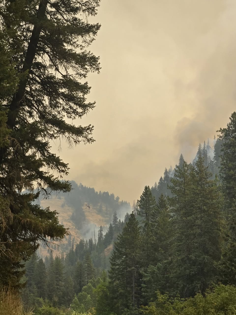
· AI Discovery

As of Aug 24, 2026, 10:15 AM MDT: The Paradise Fire is burning at 7,994 acres with 0% containment, with crews focused on patrol, mop-up, and strategic firing operations. Fire growth has remained within proposed containment lines, posing no additional threat to the public or key resources.

  • Size: 7,994 acres (per Walla Walla County Emergency Management · Facebook)
  • Containment: 0% (per Walla Walla County Emergency Management · Facebook)
  • Personnel assigned: 309 (per Walla Walla County Emergency Management · Facebook)
  • The fire grew by 258 acres the previous day, entirely within proposed containment lines, posing no additional threat to the public, Forest Service Roads 64 and 65, Mill Creek and its water intake, local utilities, or communication sites (per Walla Walla County Emergency Management · Facebook)
  • Visible satellite heat near the Mill Creek drainage has been decreasing (per Walla Walla County Emergency Management · Facebook)
  • Crews are patrolling and mopping up hot spots along the eastern edge and have identified areas for strategic firing operations to protect the watershed; smoke may be visible, particularly along the fire's southeastern edge (per Walla Walla County Emergency Management · Facebook)
  • Weather: temperatures rising into the low 80s, lower humidity, winds 5–10 mph with gusts up to 20 mph; fire activity expected to remain moderate but may increase slightly; individual trees may torch and short-distance spotting is possible (per Walla Walla County Emergency Management · Facebook)
  • A Paradise Fire Emergency Closure is in effect on the Umatilla National Forest; see fs.usda.gov for details (per Walla Walla County Emergency Management · Facebook)
  • Evacuation levels are managed by the Umatilla County Sheriff's Office, Union County Sheriff's Office, and the Confederated Tribes of the Umatilla Indian Reservation; conditions can change rapidly (per Walla Walla County Emergency Management · Facebook)
  • Fire information phone: 541-970-7128 | Email: 2026.paradise@firenet.gov | InciWeb: www.InciWeb.gov (per Walla Walla County Emergency Management · Facebook)

🤖 AI summary of official posts; may lag or contain errors — verify with the source and official channels. ⚠️ Not an official evacuation order — follow your sheriff/emergency management.
· AI Discovery

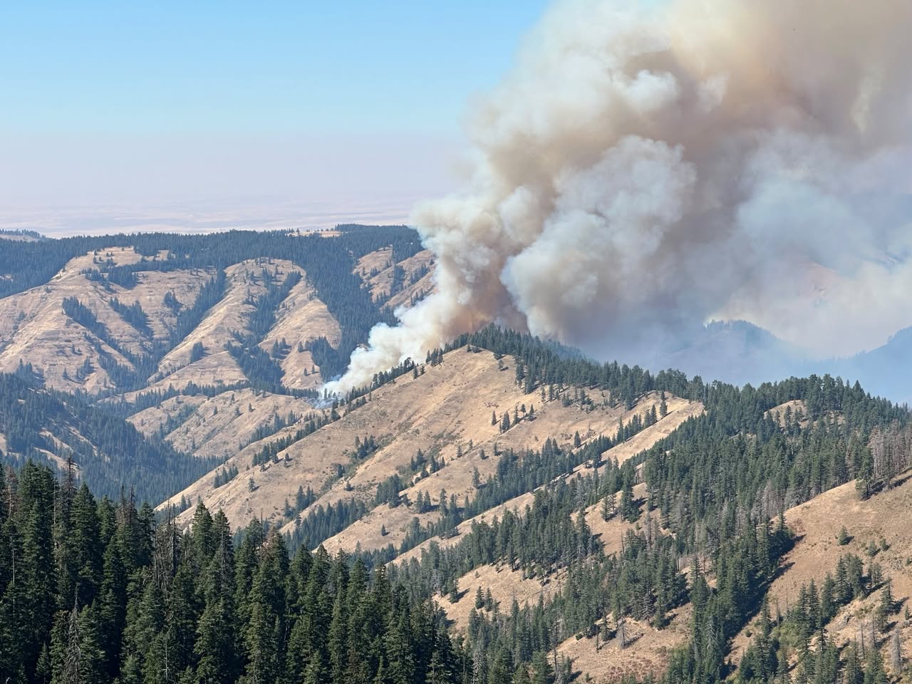
As of Aug 22, 2026, 10:45 AM MDT: The Paradise Fire is burning in the Umatilla National Forest area, with active fire behavior observed along Broken Ridge on the southwest side. The fire remains at 0% containment as of the Aug 13 update.

  • Size: 4,433 acres (per Paradise, Hagen and Horse Ridge Fire Information (Facebook) · Aug 13 update)
  • Containment: 0% (per Paradise, Hagen and Horse Ridge Fire Information (Facebook) · Aug 13 update)
  • Personnel assigned: 367 (per Paradise, Hagen and Horse Ridge Fire Information (Facebook) · Aug 13 update)
  • Active fire was observed along Broken Ridge on the southwest side, with uphill runs in grass and slower backing down steep, treed slopes, producing a sizeable plume especially in the Walla Walla area (per Paradise, Hagen and Horse Ridge Fire Information (Facebook))
  • Management action points (MAPs) have been set in partnership with local emergency managers; the fire is moving toward one MAP on the south side but has not reached it (per Paradise, Hagen and Horse Ridge Fire Information (Facebook))
  • Defensive firing along FS Road 64 was successful in creating a buffer between Broken Ridge activity and the Wilderness; this work was set to continue (per Paradise, Hagen and Horse Ridge Fire Information (Facebook))
  • An unmanned aircraft system (UAS) was used along Mill Creek to locate lingering hot spots for ground crews to address (per Paradise, Hagen and Horse Ridge Fire Information (Facebook))
  • A dozer line is in progress in the Lewis Peak area to protect structures on the west side and help contain the fire (per Paradise, Hagen and Horse Ridge Fire Information (Facebook))
  • A Paradise Fire Emergency Closure is in effect on the Umatilla National Forest (per Paradise, Hagen and Horse Ridge Fire Information (Facebook))
  • Evacuation levels are managed by the Umatilla County Sheriff's Office, Union County Sheriff's Office, and the Confederated Tribes of the Umatilla Indian Reservation; fire conditions can change rapidly and evacuation levels and road closures are frequently adjusted (per Paradise, Hagen and Horse Ridge Fire Information (Facebook))
  • Weather: Monsoonal moisture pattern expected, with a 10% chance of thunderstorms, relative humidity of 30–40%, northwest winds, and possible erratic wind gusts up to 40 mph if storms develop; lightning is possible and could cause unpredictable fire spread (per Paradise, Hagen and Horse Ridge Fire Information (Facebook))
  • Fire information phone: 541-970-7128 (8 am–8 pm, voice only); email: 2026.paradise@firenet.gov (per Paradise, Hagen and Horse Ridge Fire Information (Facebook))

🤖 AI summary of official posts; may lag or contain errors — verify with the source and official channels. ⚠️ Not an official evacuation order — follow your sheriff/emergency management.
· AI Discovery

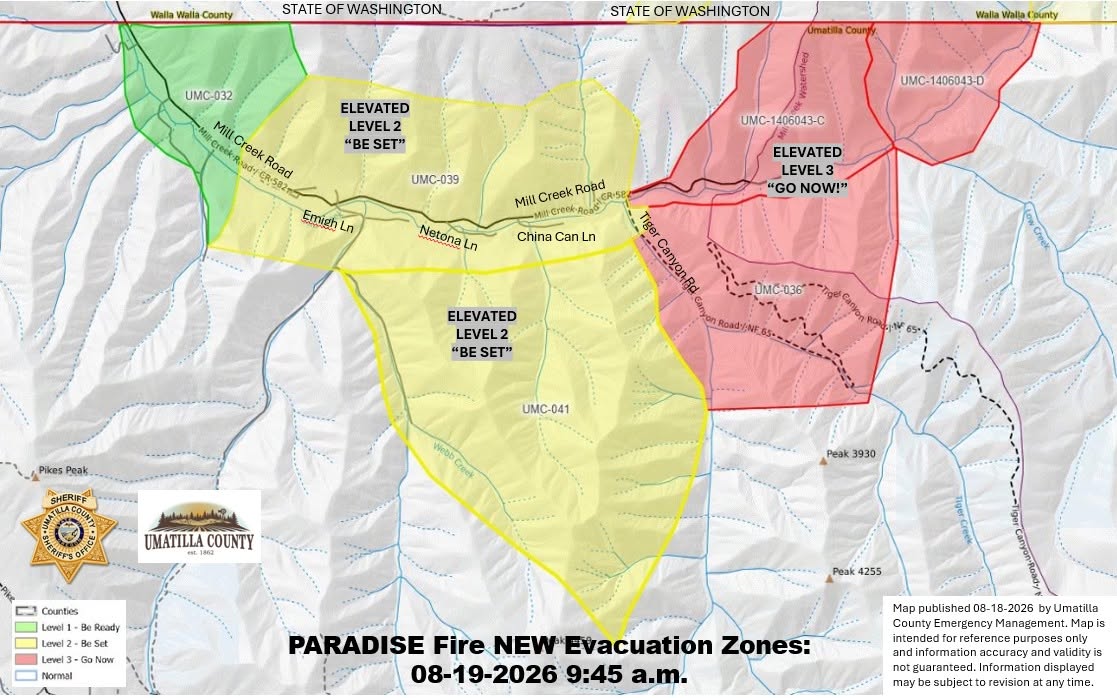
As of Aug 19, 2026, 3:05 PM MDT: The Paradise Fire in the Mill Creek Watershed is burning at 5,423 acres with 0% containment, with fire activity increasing along Low Ridge and moving toward Low Creek. Evacuation levels have been elevated in multiple Umatilla County zones, and a new Level 1 evacuation area has been issued in Washington State. Fire Size and Status Evacuation Levels — Umatilla County (Oregon) Evacuation Levels — Walla Walla County / Columbia County (Washington State) Road Closures Weather and Fire Behavior Forest Closures and Restrictions Fire information line: 541-970-7128 | Email: 2026.paradise@firenet.gov | InciWeb: www.InciWeb.gov

  • Size: 5,423 acres; Containment: 0%; Personnel: 358 (per Walla Walla County Emergency Management · Facebook and Columbia County WA E-911 and Emergency Management · Facebook)
  • Southern Area Team 3 took command of the Paradise Fire at 6 a.m. today; Incident Commander is Bart Kicklighter (per Walla Walla County Emergency Management · Facebook)
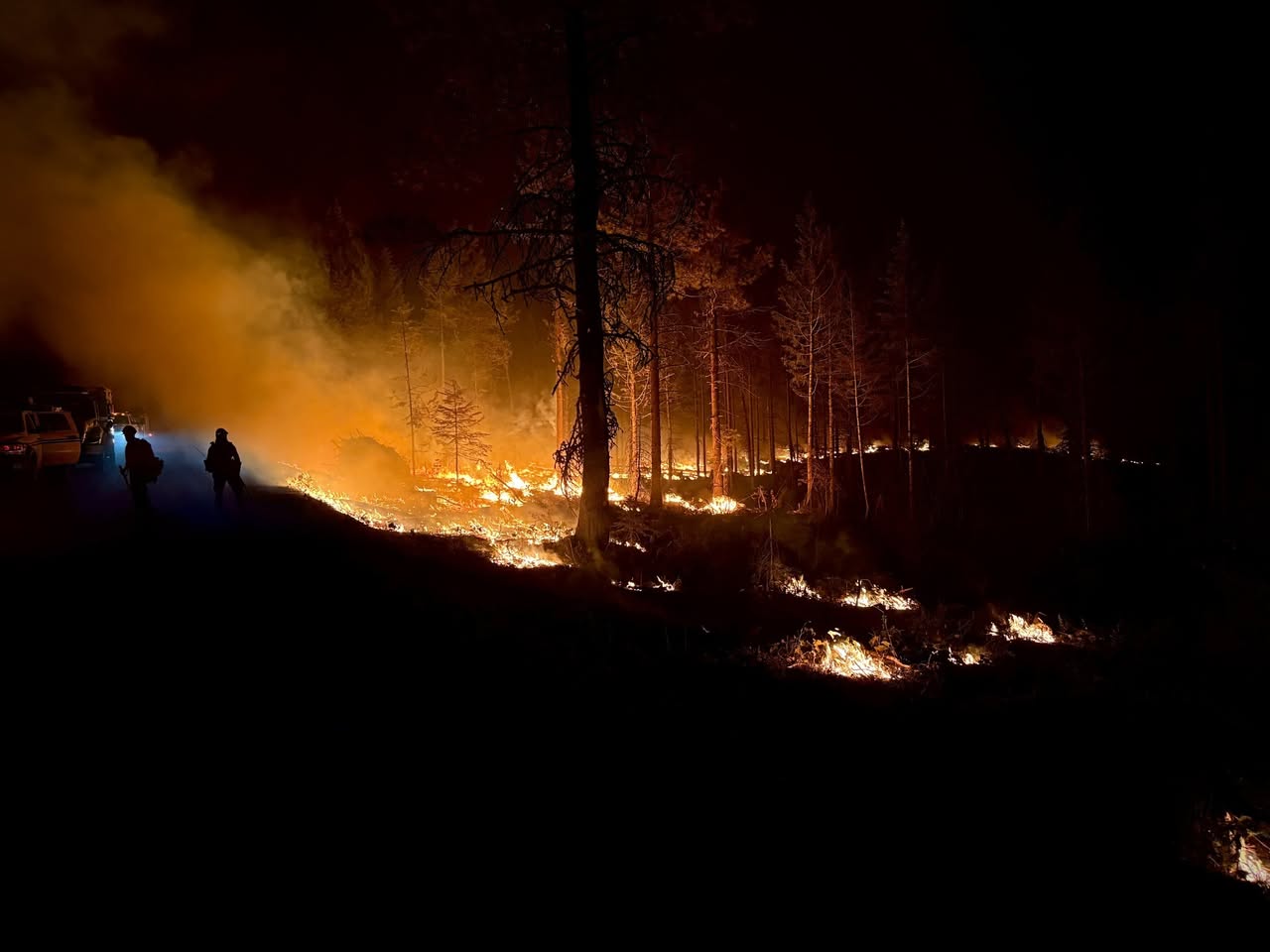
  • Fire activity increased along Low Ridge and is moving toward Low Creek; aircraft and drones helped slow the fire's spread (per Walla Walla County Emergency Management · Facebook)
  • Crews are working to improve fire control lines and securing hot spots near Forest Service Roads 64 and 65 (per Walla Walla County Emergency Management · Facebook)
  • Structure protection remains in place near Snake Ridge, Table Rock Lookout, and the water intake facilities along Mill Creek (per Walla Walla County Emergency Management · Facebook)
  • Fire personnel are monitoring fire spread toward the southwest (per Walla Walla County Emergency Management · Facebook)
  • LEVEL 3 (GO NOW): Zones UMC-036, UMC-1406043-D, and UMC-1406043-C — area east of the intersection of Mill Creek Road and Tiger Canyon Road, north to the Washington State Line, south to include Tiger Canyon Road/NF65, including the Intake Trail for the Mill Creek Watershed, north of the Mill Creek River Corridor, west of the Paradise Fire Boundary. Residents must leave immediately (per Walla Walla County Emergency Management · Facebook)
  • LEVEL 2 (GET SET): Zones UMC-039 and UMC-041 — residents on both sides of Mill Creek Road beginning 1 mile south of the Washington State Line to Tiger Creek Road, including Emigh Lane, Netona Lane, China Can Lane, and Webb Creek area (per Walla Walla County Emergency Management · Facebook)
  • LEVEL 1 (GET READY): Zone UMC-032 — first mile of Mill Creek Road south of the Washington State Line, both sides of the road; no change to this level (per Walla Walla County Emergency Management · Facebook)
  • LEVEL 1 (BE READY): The Klicker Mountain area north toward Biscuit Ridge and east toward the Walla Walla/Columbia County border has been elevated to a Level 1 "Be Ready" evacuation area, issued out of an abundance of caution in relation to the Paradise Fire (per Walla Walla County Emergency Management · Facebook; Columbia County WA E-911 and Emergency Management · Facebook; Walla Walla County Fire District #8 · Facebook)
  • Residents in the Level 1 area are asked to yield the right-of-way to emergency equipment and avoid parking vehicles, trailers, or equipment on roadsides (per Walla Walla County Emergency Management · Facebook)
  • Highway 204 remains closed; assessments are ongoing. Drivers should not proceed without confirmation from law enforcement or the Oregon Department of Transportation (per Walla Walla County Emergency Management · Facebook)
  • Afternoon highs expected in the upper 80s and low 90s; humidity dropping to 10 to 13%; winds shifting to the northwest this afternoon with ridgetop gusts around 15–18 mph (per Walla Walla County Emergency Management · Facebook)
  • Dry grass and fine fuels will ignite easily; individual or groups of trees may ignite; the fire could make short uphill runs and produce spot fires one-quarter to one-half mile ahead of the main fire (per Walla Walla County Emergency Management · Facebook)
  • Humidity will remain low into the evening, allowing fire activity to continue; the Paradise Fire may remain active on Low Ridge (per Walla Walla County Emergency Management · Facebook)
  • A Paradise Fire Emergency Closure is in effect on the Umatilla National Forest (per Walla Walla County Emergency Management · Facebook)
  • The Umatilla National Forest has issued public use restrictions for smoking, off-road travel, and chainsaw use across the entire national forest (per Walla Walla County Emergency Management · Facebook)

🤖 AI summary of official posts; may lag or contain errors — verify with the source and official channels. ⚠️ Not an official evacuation order — follow your sheriff/emergency management.
· AI Discovery

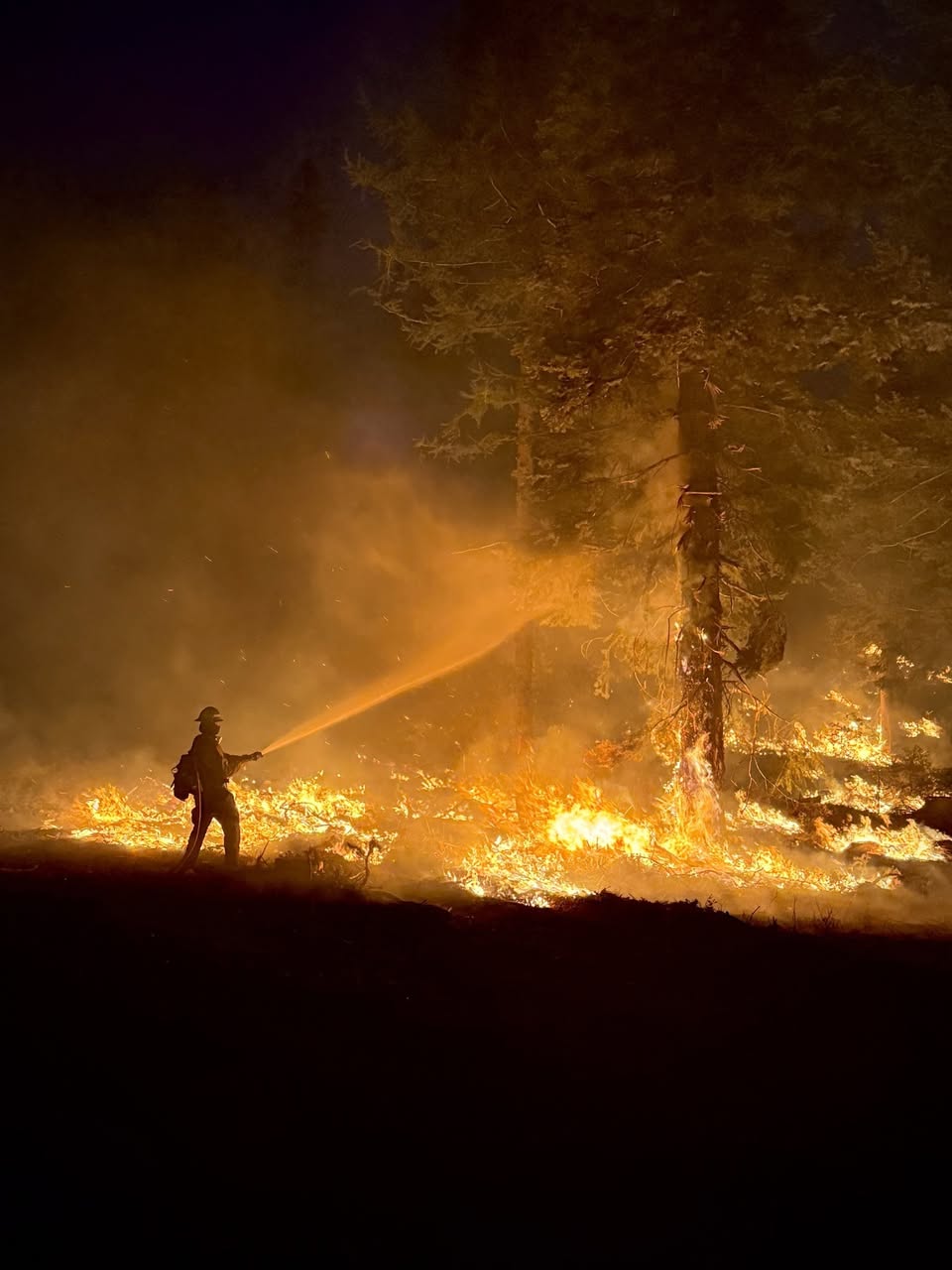
As of Aug 19, 2026, 10:59 AM MDT: The Paradise Fire (Mill Creek Watershed) has prompted elevated evacuation levels in Umatilla County following fire progress into the Low Creek area overnight. A Joint Emergency Operation Center including Umatilla County Sheriff's Office, Umatilla County Emergency Management, Union County Sheriff's Office, Union County Emergency Management, and the Confederated Tribes of the Umatilla Indian Reservation (CTUIR) remains actively engaged with Incident Management for the fire (per Umatilla County Sheriff's Office · Facebook). Residents are advised not to wait for an official evacuation order if they feel unsafe or see immediate danger. Local terrain presents significant communication and access challenges (per Umatilla County Sheriff's Office · Facebook).

  • LEVEL 3 (GO NOW) — ELEVATED: Zones UMC-036, UMC-1406043-D, and UMC-1406043-C. This area includes the area east of the intersection of Mill Creek Road and Tiger Canyon Road, north to the Washington State Line, and south to include Tiger Canyon Road/NF65, including the Intake Trail for the Mill Creek Watershed, north of the Mill Creek River Corridor, and west of the Paradise Fire Boundary. Residents should leave immediately due to imminent danger (per Umatilla County Sheriff's Office · Facebook).
  • LEVEL 2 (GET SET) — ELEVATED: Zones UMC-039 and UMC-041. This area includes residents on both sides of Mill Creek Road beginning 1 mile south of the Washington State Line to Tiger Creek Road, including Emigh Lane, Netona Lane, China Can Lane, and the Webb Creek area (per Umatilla County Sheriff's Office · Facebook).
  • LEVEL 1 (GET READY) — NO CHANGE: Zone UMC-032. This area includes the first mile of Mill Creek Road south of the Washington State Line on both sides of the road (per Umatilla County Sheriff's Office · Facebook).

🤖 AI summary of official posts; may lag or contain errors — verify with the source and official channels. ⚠️ Not an official evacuation order — follow your sheriff/emergency management.
· AI Discovery

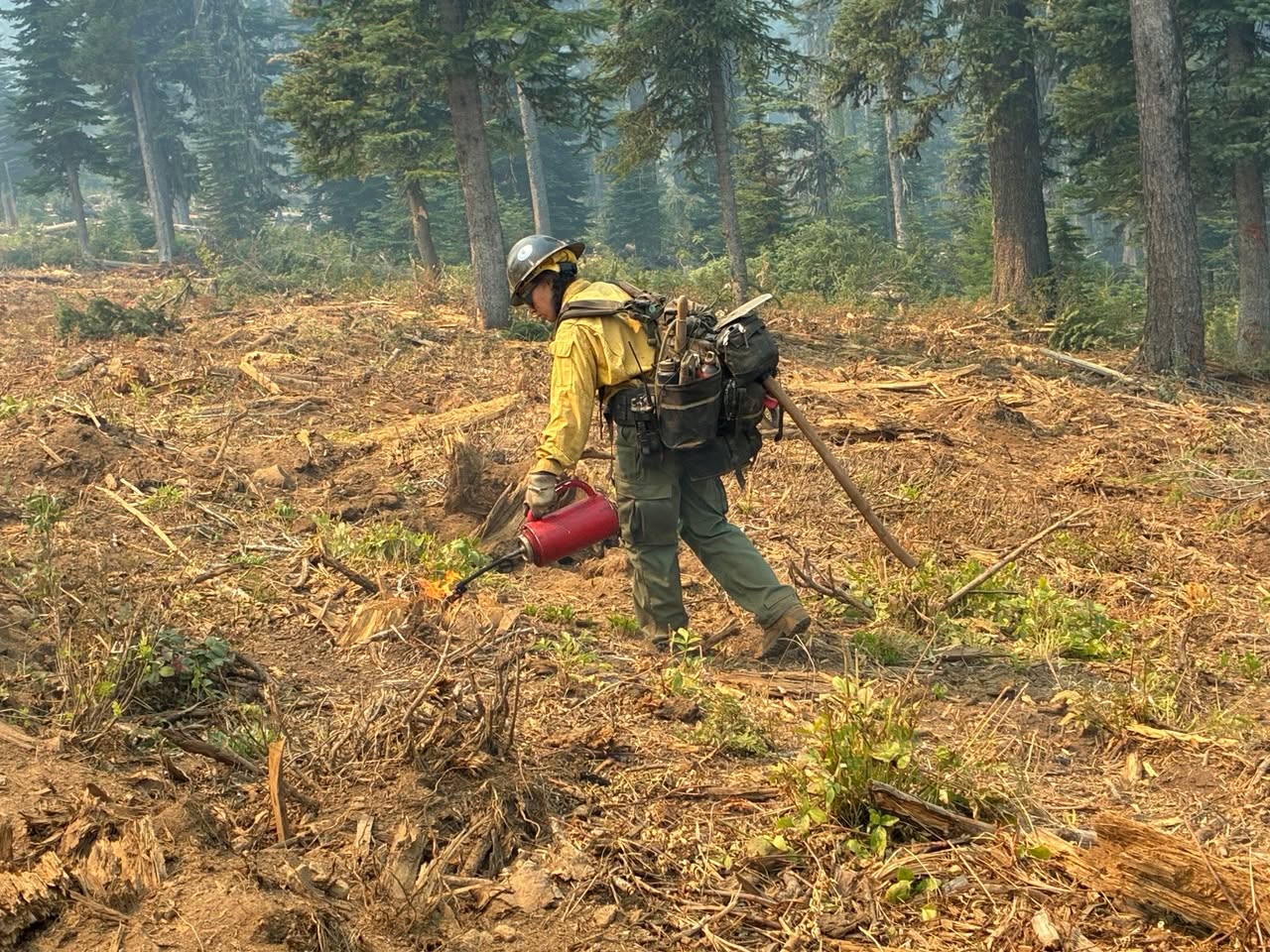
As of Aug 18, 2026, 8:12 PM MDT: The Paradise Fire (Mill Creek Watershed) has prompted increased evacuation levels in Umatilla County after the fire became established at the top of Low Ridge and began backing down toward Low Creek. A Joint Emergency Operation Center is actively engaged with the Northern Rockies Incident Management Team 6.

  • The fire became established at the top of Low Ridge and is now backing down toward Low Creek, prompting the evacuation level increases. (per Umatilla County Sheriff's Office · Facebook)
  • LEVEL 2 (BE SET) evacuations are now in effect in Umatilla County for the following zones: UMC-036 (NEW), UMC-1406043-D (No Change), UMC-1406043-C (No Change). This area covers east of the intersection of Mill Creek Road and Tiger Canyon Road, north to the Washington State Line, and south to include Tiger Canyon Road/NF65, including the Intake Trail for the Mill Creek Watershed, North of the Mill Creek River Corridor, West of the Paradise Fire Boundary. (per Umatilla County Sheriff's Office · Facebook)
  • LEVEL 1 (BE READY) evacuations remain in effect in Umatilla County for zones UMC-039, UMC-041, and UMC-032. This area covers residents on both sides of Mill Creek Road from the Washington State Line to Tiger Creek Road, including Emigh Lane, Netona Lane, China Can Lane, and the Webb Creek area. (per Umatilla County Sheriff's Office · Facebook)
  • The Joint Emergency Operation Center includes the Umatilla County Sheriff's Office, Umatilla County Emergency Management, Union County Sheriff's Office, Union County Emergency Management, and the Confederated Tribes of the Umatilla Indian Reservation (CTUIR). (per Umatilla County Sheriff's Office · Facebook)
  • Fire conditions can change rapidly and unpredictably. Residents should not wait for an official evacuation order if they feel unsafe or see immediate danger. (per Umatilla County Sheriff's Office · Facebook)
  • Emergency alerts can be registered at oralert.gov. (per Umatilla County Sheriff's Office · Facebook)

🤖 AI summary of official posts; may lag or contain errors — verify with the source and official channels. ⚠️ Not an official evacuation order — follow your sheriff/emergency management.

· AI Discovery

As of Aug 18, 2026, 6:17 PM MDT: Fire activity on the Paradise Fire increased today under challenging weather conditions, with a spot fire crossing Broken Creek and becoming established on the west side. Highway 204 remains closed and current evacuation levels remain in place.

  • A spot fire crossed Broken Creek and became established along the west side, making a run toward the top of Low Ridge. Fire managers anticipated this possibility and have initiated their planned mitigation activities. Smoke is expected to be visible through the evening. (per Umatilla County Sheriff's Office · Facebook)
  • A single tree spotted across Mill Creek; a Felling Module, specialized timber fallers and crew are on scene along with 2 helicopters for water drops to quickly minimize the impact of the spot. (per Umatilla County Sheriff's Office · Facebook)
  • Highway 204 remains closed. (per Umatilla County Sheriff's Office · Facebook; per Walla Walla County Emergency Management · Facebook)
  • Current evacuation levels remain in place. (per Umatilla County Sheriff's Office · Facebook; per Walla Walla County Emergency Management · Facebook)

🤖 AI summary of official posts; may lag or contain errors — verify with the source and official channels. ⚠️ Not an official evacuation order — follow your sheriff/emergency management.

· AI Discovery

As of Aug 18, 2026, 10:36 AM MDT: The Paradise Fire is burning at 5,423 acres with 0% containment, and near critical fire weather is expected to increase fire activity. A new incident management team is transitioning in to take command on August 19th.

  • Size: 5,423 acres (per Walla Walla County Emergency Management · Facebook)
  • Containment: 0% (per Walla Walla County Emergency Management · Facebook)
  • Personnel assigned: 349 (per Walla Walla County Emergency Management · Facebook)
  • Fire information phone: 541-970-7128, available 8 am–8 pm; voice only, texts not received (per Walla Walla County Emergency Management · Facebook)
  • Fire information email: 2026.paradise@firenet.gov (per Walla Walla County Emergency Management · Facebook)
  • Southern Area Team 3 is transitioning in to take command from Northern Rockies Team 6 on Wednesday, August 19th (per Walla Walla County Emergency Management · Facebook)
  • Near critical fire weather is expected over the fire area, with relative humidity of 18–20% and wind gusts around 20 mph; an increase in fire activity is expected (per Walla Walla County Emergency Management · Facebook)
  • Defensive firing continued in the southeast portion of the fire along FS Road 64, extending fire lines and creating depth (per Walla Walla County Emergency Management · Facebook)
  • UAS drones are continuing to assist ground resources using infrared cameras to pick up heat signatures (per Walla Walla County Emergency Management · Facebook)
  • On the northern side, resources are monitoring the fire's edge to keep the footprint minimal in the Mill Creek watershed (per Walla Walla County Emergency Management · Facebook)
  • Chipping and mastication efforts are continuing around the fire perimeter to reduce fuels (per Walla Walla County Emergency Management · Facebook)
  • A Paradise Fire Emergency Closure is in effect on the Umatilla National Forest (per Walla Walla County Emergency Management · Facebook)
  • Umatilla National Forest public use restrictions are in effect for smoking, off-road travel, and chainsaw use across the entire national forest (per Walla Walla County Emergency Management · Facebook)
  • Evacuation levels are managed by the Umatilla County Sheriff's Office, Union County Sheriff's Office, and the Confederated Tribes of the Umatilla Indian Reservation; fire conditions can change rapidly and evacuation levels and road closures are frequently adjusted (per Walla Walla County Emergency Management · Facebook)

🤖 AI summary of official posts; may lag or contain errors — verify with the source and official channels. ⚠️ Not an official evacuation order — follow your sheriff/emergency management.

· AI Discovery

As of Aug 17, 2026, 10:41 AM MDT: The Paradise Fire is burning at 5,333 acres with 0% containment, with fire activity remaining moderate but increasing as fuels dry. Fire managers are focused on establishing containment lines along the south and east flanks.

  • Size: 5,333 acres (per Columbia County WA E-911 and Emergency Management · Facebook)
  • Containment: 0% (per Columbia County WA E-911 and Emergency Management · Facebook)
  • Personnel assigned: 353 (per Columbia County WA E-911 and Emergency Management · Facebook)
  • Fire behavior on Sunday included creeping, smoldering, and backing fire throughout the fire area; fire is slowly backing down slope on Broken Ridge toward Mill Creek (per Columbia County WA E-911 and Emergency Management · Facebook)
  • Line improvement operations were successful along portions of FSR 65 and will continue Monday; firefighters are also moving east from the Mill Creek side to tie into the road system (per Columbia County WA E-911 and Emergency Management · Facebook)
  • A new, small fire was discovered south of the Paradise Fire on Sunday, resulting from a lightning strike during previous thunderstorms; a crew and aerial support from the Paradise Fire responded and helped with containment (per Columbia County WA E-911 and Emergency Management · Facebook)
  • Weather: 10% chance of isolated thunderstorms Monday, tapering off Tuesday, when a warming and drying trend begins with afternoon gusty winds up to 20 mph and temperatures in the mid-80s across higher elevations (per Columbia County WA E-911 and Emergency Management · Facebook)
  • A Paradise Fire Emergency Closure is in effect on the Umatilla National Forest; details at https://www.fs.usda.gov/r06/umatilla/alerts/paradise-fire-emergency-closure (per Columbia County WA E-911 and Emergency Management · Facebook)
  • Evacuation levels are managed by the Umatilla County Sheriff's Office, Union County Sheriff's Office, and the Confederated Tribes of the Umatilla Indian Reservation; residents should check those agencies directly as conditions can change rapidly (per Columbia County WA E-911 and Emergency Management · Facebook)
  • Fire information phone: 541-970-7128, available 8 AM–8 PM; voice only (per Columbia County WA E-911 and Emergency Management · Facebook)

🤖 AI summary of official posts; may lag or contain errors — verify with the source and official channels. ⚠️ Not an official evacuation order — follow your sheriff/emergency management.

· AI Discovery

As of Aug 14, 2026, 8:52 PM MDT: The Paradise Fire made an uphill run on its north side during clearer weather today, while firefighters worked to strengthen and widen containment lines on multiple flanks of the fire.

  • With clearer weather, the Paradise Fire made an uphill run on the north side of the fire. (per Walla Walla County Emergency Management · Facebook, Umatilla County Sheriff's Office · Facebook, and Union County Emergency Services · Facebook)
  • Protection efforts at Mill Creek held, preventing further fire spread in that area. (per Walla Walla County Emergency Management · Facebook, Umatilla County Sheriff's Office · Facebook, and Union County Emergency Services · Facebook)
  • On the west/northwest side, bulldozers tied containment line into an old roadway, strengthening the line and improving its defensibility. (per Walla Walla County Emergency Management · Facebook, Umatilla County Sheriff's Office · Facebook, and Union County Emergency Services · Facebook)
  • Defensive firing operations occurred on the east and southeast sides of the fire, widening and reinforcing containment lines there to create a stronger, more defensible break. (per Walla Walla County Emergency Management · Facebook, Umatilla County Sheriff's Office · Facebook, and Union County Emergency Services · Facebook)

🤖 AI summary of official posts; may lag or contain errors — verify with the source and official channels.

· AI Discovery

As of Aug 13, 2026, 9:41 AM MDT: The Paradise Fire is burning in the Umatilla National Forest area with no containment established. Firefighters are working to protect structures and create defensive lines while monitoring a key management action point on the fire's south side.

  • Size: 4,433 acres (per Umatilla County Sheriff's Office · Facebook)
  • Containment: 0% (per Umatilla County Sheriff's Office · Facebook)
  • Personnel assigned: 367 (per Umatilla County Sheriff's Office · Facebook)
  • On Wednesday, firefighters observed active fire along Broken Ridge on the southwest side of the fire, with uphill runs in grass and slower backing down steep, treed slopes (per Umatilla County Sheriff's Office · Facebook)
  • A sizeable smoke plume was visible, especially in the Walla Walla area (per Umatilla County Sheriff's Office · Facebook)
  • The fire is moving toward a management action point (MAP) on the south side but has not reached it yet (per Umatilla County Sheriff's Office · Facebook)
  • Defensive firing along FS Road 64 was successful in creating a buffer between Broken Ridge activity and the Wilderness; this work will continue Thursday (per Umatilla County Sheriff's Office · Facebook)
  • A UAS was used along Mill Creek to locate lingering hot spots for ground crews to address (per Umatilla County Sheriff's Office · Facebook)
  • A dozer line is in progress in the Lewis Peak area to protect structures on the west side and help contain the fire (per Umatilla County Sheriff's Office · Facebook)
  • A Umatilla National Forest emergency closure is in effect for the Paradise Fire (per Umatilla County Sheriff's Office · Facebook)
  • Thunderstorms are possible Thursday afternoon or evening, with erratic wind gusts up to 40 mph and lightning possible, which could cause unpredictable fire spread (per Umatilla County Sheriff's Office · Facebook)
  • Fire information phone: 541-970-7128 (8 am–8 pm; voice only); email: 2026.paradise@firenet.gov (per Umatilla County Sheriff's Office · Facebook)
  • Evacuation levels are managed by Umatilla County Sheriff's Office, Union County Sheriff's Office, and the Confederated Tribes of the Umatilla Indian Reservation — check respective county emergency management websites for current status (per Umatilla County Sheriff's Office · Facebook)

🤖 AI summary of official posts; may lag or contain errors — verify with the source and official channels. ⚠️ Not an official evacuation order — follow your sheriff/emergency management.

Know if this fire gets close to you.Set an alert zone and get a push if a fire comes near it or grows — free.Follow this fire

Don't refresh this page. Let it find you.

  • Alerts when it heads your way — a push if the fire comes within your zone's radius, gets closer, or grows sharply.
  • Live perimeter & growth — watch the fire move on the map as agencies update it.
  • Draw a zone around home — or anywhere your people are — and get the lead time to act.

Free · iPhone & iPad · Official + local sources · Start as a guest, no account needed

Example alerts

Data from official wildfire feeds and local agencies, refreshed regularly but not guaranteed real-time. Always follow official evacuation orders from local authorities.

Paradise FireSignificant · 9,656 ac · 86% containedFollow