Active incidentUpdated

Active Wildfire · Kittitas County, WA

GOAT Firenear Kittitas County, WA

Opens in the app — start as a guest, no account needed

64%
Contained
Size
815acres
Status
Active
Discovered

From the ground

Latest photos from the fire

6 images · gathered by AI Discovery from official & local sources

Photos are gathered from official agency and local social sources and shown with attribution. Always follow official evacuation orders.

Live in the appPerimeter & evacuation zones update as agencies publish them.Open live map →
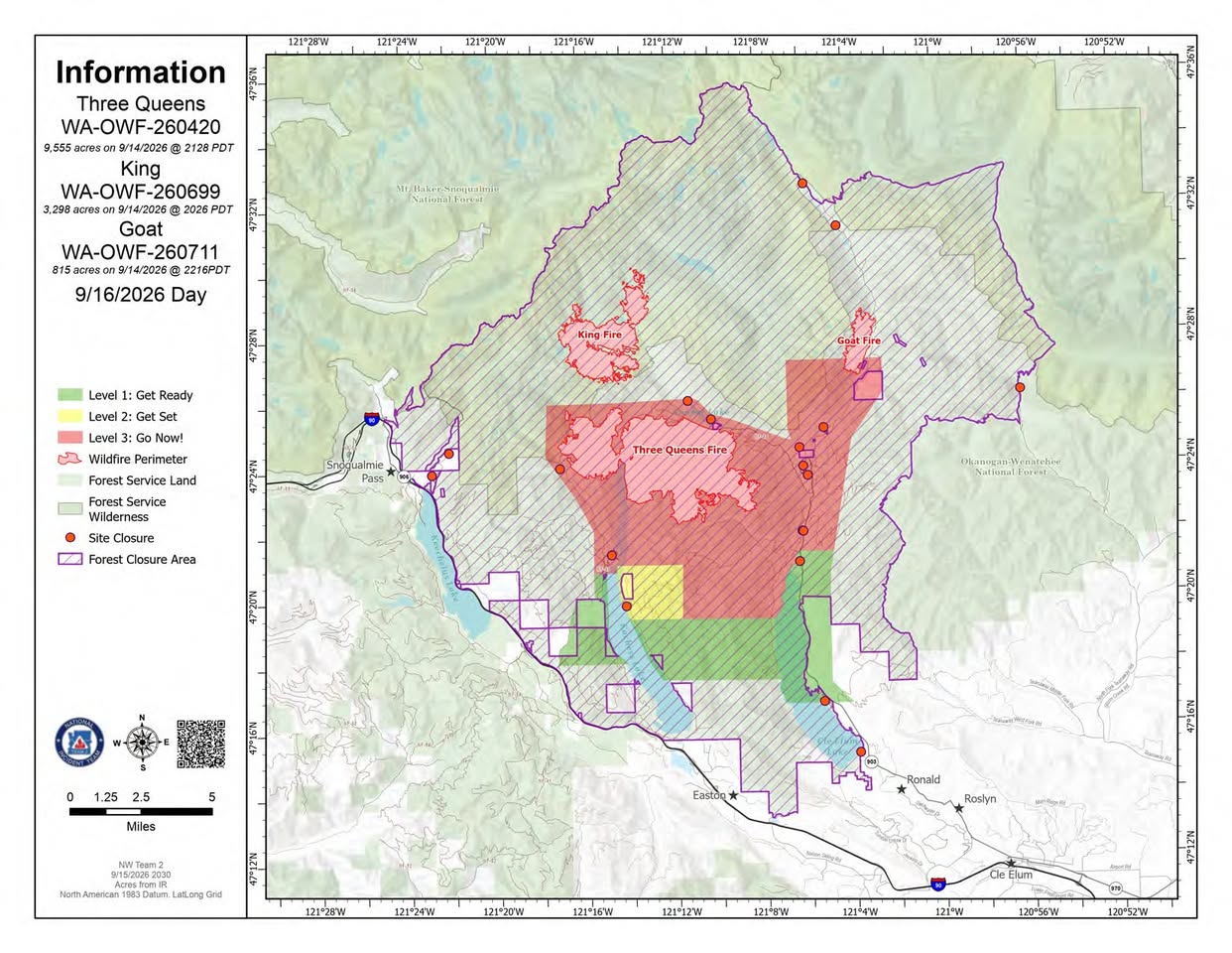
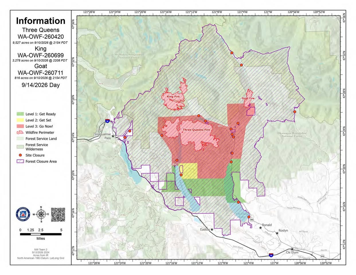
Current fire perimeter815 acres · updated

Updates

WFIGS·

Containment updated from 41% to 64%.

InciWeb·

WAOWF Goat Fire: Last updated: 2026-09-17 --- The type of incident is Wildfire and involves the following unit(s) Okanogan-Wenatchee National Forest. --- State: Washington --- Coordinates: Latitude: 47° 27 32 Longitud...

WFIGS·

Containment updated from 22% to 41%. Personnel updated to 31.
· AI Discovery

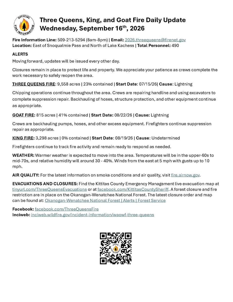
As of Sep 16, 2026, 9:30 AM MDT: The Goat Fire is burning east of Snoqualmie Pass and north of Lake Kachess, with containment continuing to progress. Crews are transitioning to equipment removal and suppression repair work.

  • Size: 815 acres (per Kittitas County Fire District 7 · Facebook)
  • Containment: 41% (per Kittitas County Fire District 7 · Facebook)
  • Start date: August 22, 2026 (per Kittitas County Fire District 7 · Facebook)
  • Cause: Lightning (per Kittitas County Fire District 7 · Facebook)
  • Current operations: Crews are backhauling pumps, hoses, and other excess equipment, and continuing suppression repair as appropriate (per Kittitas County Fire District 7 · Facebook)
  • Weather: Warmer conditions expected, with temperatures in the upper-60s to mid-70s, relative humidity around 30–40%, and east winds at 5 mph with gusts up to 10 mph (per Kittitas County Fire District 7 · Facebook)
  • Evacuations and closures: A live evacuation map is available through Kittitas County Emergency Management; a forest closure and fire restriction are in place on the Okanogan-Wenatchee National Forest (per Kittitas County Fire District 7 · Facebook)
  • Updates will now be issued every other day (per Kittitas County Fire District 7 · Facebook)
  • Fire information line: 509-213-5294, available 8 AM–8 PM (per Kittitas County Fire District 7 · Facebook)

🤖 AI summary of official posts; may lag or contain errors — verify with the source and official channels. ⚠️ Not an official evacuation order — follow your sheriff/emergency management.

InciWeb·

WAOWF Goat Fire: Last updated: 2026-09-16 --- The type of incident is Wildfire and involves the following unit(s) Okanogan-Wenatchee National Forest. --- State: Washington --- Coordinates: Latitude: 47° 27 32 Longitud...

WFIGS·

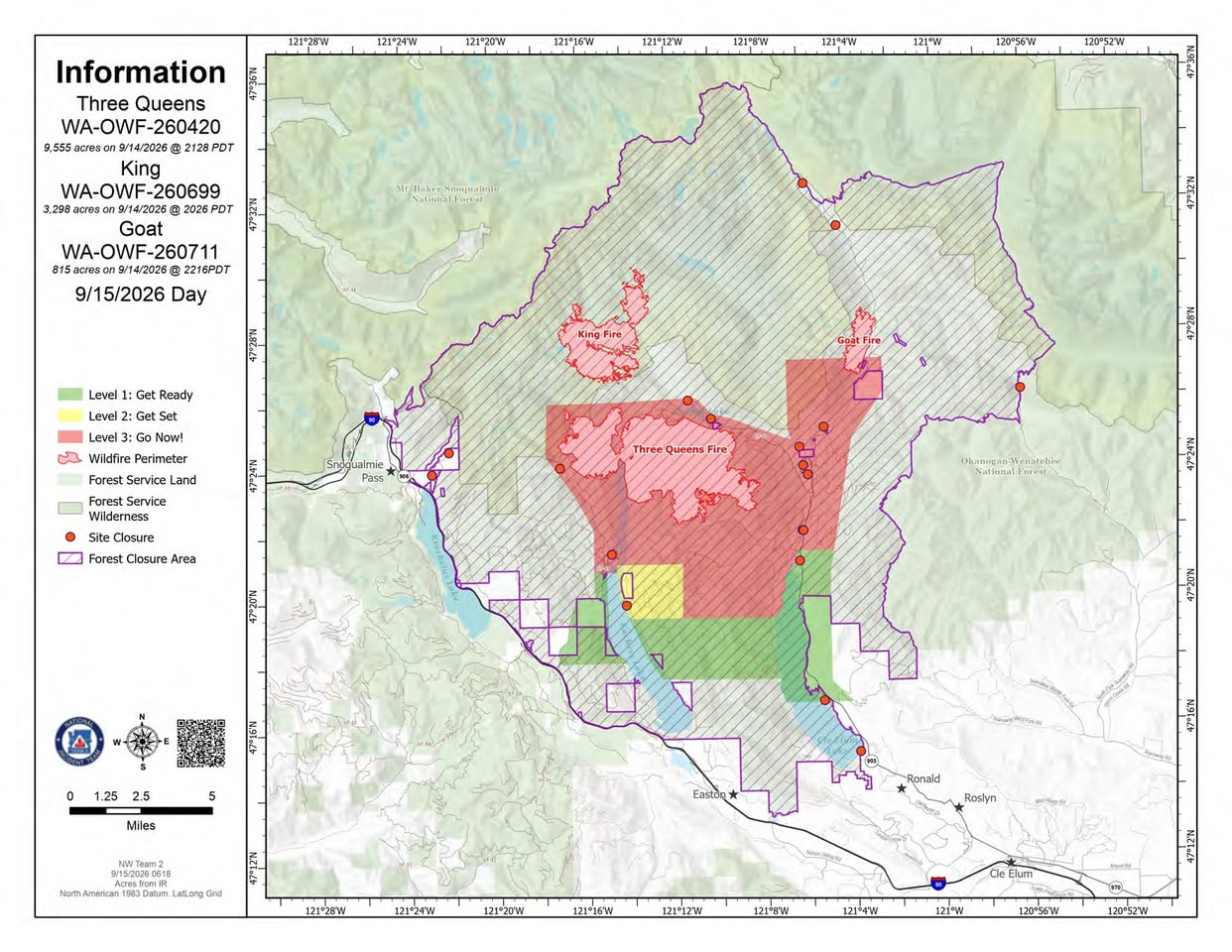
Acreage updated from 816 to 815 acres. Personnel updated to 44.
· AI Discovery

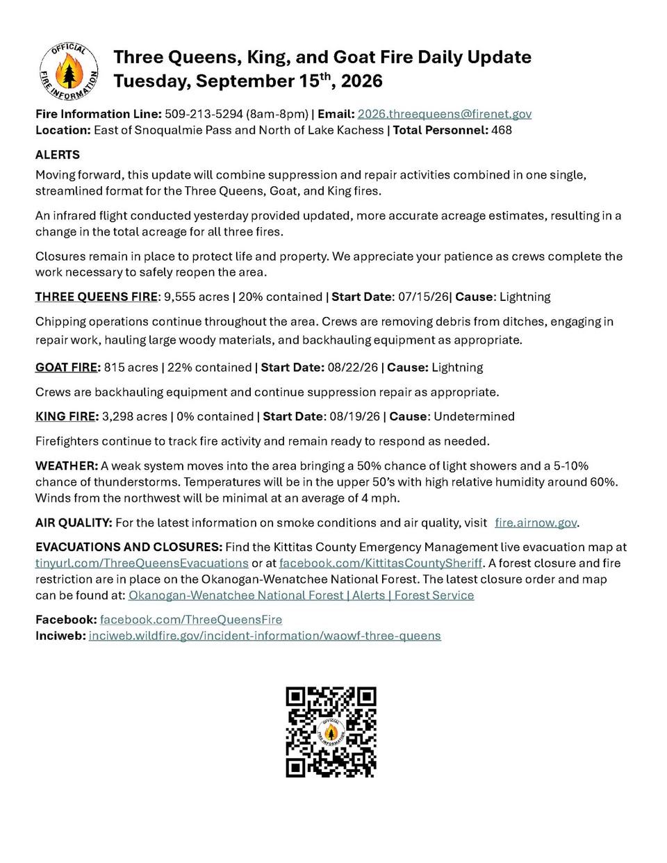
As of Sep 15, 2026, 10:09 AM MDT: The Goat Fire is burning east of Snoqualmie Pass and north of Lake Kachess, with crews continuing suppression repair and equipment backhaul operations.

  • Size: 815 acres (per Kittitas County Fire District 7 · Facebook)
  • Containment: 22% (per Kittitas County Fire District 7 · Facebook)
  • Start date: August 22, 2026 (per Kittitas County Fire District 7 · Facebook)
  • Cause: Lightning (per Kittitas County Fire District 7 · Facebook)
  • Note: Acreage was updated following an infrared flight conducted on September 14, 2026, which provided more accurate estimates (per Kittitas County Fire District 7 · Facebook)
  • Total personnel across the Three Queens, Goat, and King fires combined: 468 (per Kittitas County Fire District 7 · Facebook)
  • Weather: 50% chance of light showers, 5–10% chance of thunderstorms; temperatures in the upper 50s; relative humidity around 60%; northwest winds averaging 4 mph (per Kittitas County Fire District 7 · Facebook)
  • Evacuations and closures: Active evacuation map available at tinyurl.com/ThreeQueensEvacuations or facebook.com/KittitasCountySheriff; a forest closure and fire restriction are in place on the Okanogan-Wenatchee National Forest (per Kittitas County Fire District 7 · Facebook)
  • Fire information line: 509-213-5294, available 8 AM–8 PM (per Kittitas County Fire District 7 · Facebook)

🤖 AI summary of official posts; may lag or contain errors — verify with the source and official channels. ⚠️ Not an official evacuation order — follow your sheriff/emergency management.

InciWeb·

WAOWF Goat Fire: Last updated: 2026-09-15 --- The type of incident is Wildfire and involves the following unit(s) Okanogan-Wenatchee National Forest. --- State: Washington --- Coordinates: Latitude: 47° 27 32 Longitud...

WFIGS·

Personnel updated to 32.

· AI Discovery

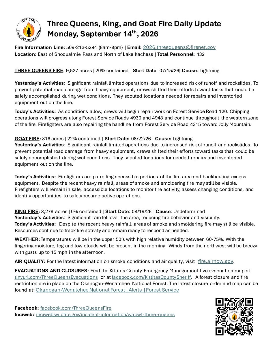
As of Sep 14, 2026, 10:05 AM MDT: The Goat Fire is burning east of Snoqualmie Pass and north of Lake Kachess, with recent significant rainfall limiting operations and reducing fire activity. Firefighters are monitoring conditions and preparing to resume active operations as weather allows.

  • Size: 816 acres (per Kittitas County Fire District 7 · Facebook)
  • Containment: 22% (per Kittitas County Fire District 7 · Facebook)
  • Start date: August 22, 2026 (per Kittitas County Fire District 7 · Facebook)
  • Cause: Lightning (per Kittitas County Fire District 7 · Facebook)
  • Total personnel on the broader incident complex: 448 (per Kittitas County Fire District 7 · Facebook)
  • Yesterday's activities: Significant rainfall limited operations due to increased risk of runoff and rockslides; crews scouted locations for needed repairs and inventoried equipment on the line (per Kittitas County Fire District 7 · Facebook)
  • Today's activities: Firefighters are patrolling accessible portions of the fire area and backhauling excess equipment; areas of smoke and smoldering fire may still be visible despite recent heavy rainfall; firefighters will remain in safe, accessible locations to monitor fire activity, assess changing conditions, and identify opportunities to safely resume active operations (per Kittitas County Fire District 7 · Facebook)
  • Weather: Temperatures in the upper 50s, relative humidity 60–75%, fog and low clouds expected in the morning, northwest winds with gusts up to 15 mph in the afternoon (per Kittitas County Fire District 7 · Facebook)
  • Evacuations and closures: Live evacuation map available via Kittitas County Emergency Management; a forest closure and fire restriction are in place on the Okanogan-Wenatchee National Forest (per Kittitas County Fire District 7 · Facebook)
  • Fire information line: 509-213-5294, available 8 AM–8 PM (per Kittitas County Fire District 7 · Facebook)

🤖 AI summary of official posts; may lag or contain errors — verify with the source and official channels. ⚠️ Not an official evacuation order — follow your sheriff/emergency management.

InciWeb·

WAOWF Goat Fire: Last updated: 2026-09-14 --- The type of incident is Wildfire and involves the following unit(s) Okanogan-Wenatchee National Forest. --- State: Washington --- Coordinates: Latitude: 47° 27 32 Longitud...

WFIGS·

Personnel updated to 33.

InciWeb·

WAOWF Goat Fire: Last updated: 2026-09-13 --- The type of incident is Wildfire and involves the following unit(s) Okanogan-Wenatchee National Forest. --- State: Washington --- Coordinates: Latitude: 47° 27 32 Longitud...

WFIGS·

Personnel updated to 39.

InciWeb·

WAOWF Goat Fire: Last updated: 2026-09-12 --- The type of incident is Wildfire and involves the following unit(s) Okanogan-Wenatchee National Forest. --- State: Washington --- Coordinates: Latitude: 47° 27 32 Longitud...

WFIGS·

Acreage updated from 813 to 816 acres. Containment updated from 3% to 22%. Personnel updated to 70.

InciWeb· First report

First report.

WAOWF Goat Fire: Last updated: 2026-09-11 --- The type of incident is Wildfire and involves the following unit(s) Okanogan-Wenatchee National Forest. --- State: Washington --- Coordinates: Latitude: 47° 27 32 Longitud...

Get updates like this the moment they happen.Push alerts for new evacuations, growth & containment changes — free.Follow this fire

Don't refresh this page. Let it find you.

  • Evacuation alerts for your zone — pushed as soon as we see an order, not hours later.
  • Live perimeter & growth — watch the fire move on the map as agencies update it.
  • Draw a zone around home — or anywhere your people are — and get the lead time to act.

Free · iPhone & iPad · Official + local sources · Start as a guest, no account needed

Example alerts

Data from official wildfire feeds and local agencies, refreshed regularly but not guaranteed real-time. Always follow official evacuation orders from local authorities.

GOAT FireActive · 815 ac · 64% containedFollow